Tuesday, January 17, 2023

Arthur of Cornwall or Arthur of the Cornovium that was Badbury/Liddington Castle?


Durocornovium and the Roman Roads (Courtesy https://sashamaps.net/docs/maps/roman-roads-of-britain/)

Quite a long time ago I entertained the idea - not very seriously - that Arthur's Cernyw or Cornwall could be a reflection of Durocornovium, a site literally right next to both Barbury Castle and Liddington Castle/Badbury (one of the candidates for Arthur's Badon). 

But now that I am quite certain that Illtud = Uther, and given that no other father for the legendary Arthur other than Uther has been put forward by the Welsh tradition, and given that Illtud was born in the 'Llydaw' that is actually the Leadon Vale, part of the old Dobunni kingdom, and given that the old Dobunni kingdom included Durocornovium, Barbury Castle and Liddington Castle, I must reconsider that which I once dispensed with, i.e. Arthur was operating militarily in the region that included Durocornovium.  And that means that the traditional assignment of Arthur to Cornwall/Cernyw may be a folkloristic relocation of Durocornovium.

To my mind, the only real question at this point is what does Durocornovium actually mean. It it this question to which I will address myself for the remainder of this blog post.

There are, essentially, two theories regarding Durocornovium.  One is that a group of the Welsh Cornovii tribe were settled at the new Roman city or that they may have been a garrison at a fort there.  The other has the name be purely local, perhaps for a geological feature, such as a horn-shaped extension of higher land.  Certainly, a case could be made for this last, given the topography of the region.  
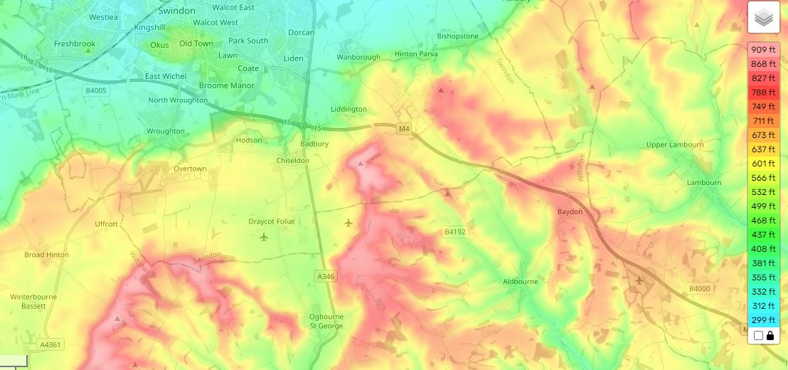


My guess for the "horn" would be the situation of Upper Wanborough, which lies between Nythe Farm and Liddington Castle. From http://www.british-history.ac.uk/vch/wilts/vol9/pp174-186:

"Geographically the parish is divided roughly in half, the southern section lying on the chalk downs. The shape of the parish conforms to a pattern found along the scarp slope of the Chalk both westwards into Wiltshire and eastwards into Berkshire, each parish having chalk uplands as well as greensands and clays for meadow and pasture. (fn. 7) Upper Wanborough, around the church, is on an Upper Greensand spur [emphasis mine] commanding a view north over Lower Wanborough and south over Liddington. The northern half of the parish towards the shallow valley of the River Cole is successively Gault, Lower Greensand, and Kimmeridge Clay. (fn. 8) The chalk scarp rises behind the village, reaching 800 ft. at Foxhill on the parish boundary. Most of the Chalk lies between 600 ft. and 700 ft. Two coombs pierce the eastern boundary between the Ridge Way and the Icknield Way, the larger containing two chalk pits. Below the scarp the land falls gently away to the river, to below 300 ft., and is drained by the Cole, its tributary stream the Lidd [for which Liddington was named], and several smaller streams, providing abundant meadow land and marsh. There is little wood in the parish, although there is evidence of illegal felling during the 16th century. (fn. 9) Stone was quarried at Berrycombe in the 16th century (fn. 10) and marl was taken from Inlands at least from the end of the 13th century. (fn. 11)"

A spur of land or a section jutting out between two coombs could be construed as a "horn of land" and so Cornovium may have been used here in the same sense as it was for Cornwall (Cernyw), which was a horn of land jutting out into the sea. 

I am posting here some nice selections from Rivet and Smith (THE PLACE-NAMES OF ROMAN BRITAIN) and other respectable sources on the Durocornovium place-name, and the Cornovii tribal designation in general.  

"Note. The two names Durocornovium (qq.v.) indicate the presence of Cornovii also in Cornwall and Wiltshire. In Cornwall (to which they ultimately gave its name) they were presumably either a subdivision or a client-tribe of the Dumnonii and the appearance of the place-name in Ravenna suggests that they were there before any supposed migration from the Shropshire area in the fifth century (e.g. J. Morris, The Age of Arthur (London, 1973), 68-69). The name in Wiltshire is unexplained, but it might represent a group who settled there in the course of an early migration or the early garrison of a fort."


There were other Cornovii in Britain, including a group in the extreme north of Scotland:

"The base of these names is British *corn- 'horn' (Welsh and Irish corn; Latin cornu) and it has been suggested (Watson CPNS 16) that the British peoples were so called because they lived on 'horns' of land, promontories. In the case of Cornwall C. Thomas (Rural settlement in roman Britain (London, 1966), 86) has plausibly argued that the Cornovii there, as Venetic immigrants, might have been given the name by the Dumnonii because they dwelt in promontory forts (cliff-castles), but in Cheschire (where the wirral peninsula would be involved) and in Caithness to interpret the name geographically is probably to use the perception of moderns accustomed to looking at maps. For the people of Shrophire and Cheshire the vertical 'horn' of the Wrekin might conceivably be invoked, but this would not explain those of Caithness. Ross( 1967) 143 thinks that peoples do not neme themselves in this way and that the Cornovii are rather 'worshippers of a horned deity of the Cernunnos (stag-god) type', which is surely preferable.

IDENTIFICATION. A people of Scotland, placed furthest 'east' (i.e. north-east) by Ptolemy and so to be locatcd in Caithness."


Most authorities do hold to the Cornovii of Durocornovium being a tribal designation, although one possibly based on a local geographical feature:


"The Roman town of Durocornovium was located at Covingham, the junction of two Roman roads, the Ermin Way and the road south to Mildenhall (Cunetio). The Ermin Way connected London via Silchester ( Calleva Atrebatum ) to Cirencester ( Corinium Dobunnorum ), the second largest Roman town after London.

Durocornovium was founded in the First Century as a military camp but it became a merchant town covering more than sixty acres & having a population of several thousand at its peak in 350AD.

Duro is a Celtic word meaning "door" or "enclosed market, square, forum, walled town, village"

Cornovium may either be a common noun in Brittonic meaning "horn, peninsula", or derive from the British Cornovii people of the Midlands , based around Wroxeter ; alternately, we may have or an identically-named tribe from the area of Durocornovium."

To date, no archaeological evidence for a Dark Age battle has been found at Liddington Castle near Durocornovium.  I have been given an important recent paper on the subject from Professor Richard Bradley and am offering the Conclusions section of that study below:


"Archaeol.J., 153 (1996), 1-59
Liddington Castle and the Battle of Badon:
Excavations and Research 1976
By SUSAN HIRST and PHILIP RAHTZ
with contributions by EMMA ASHTON, RICHARD BRADLEY, HuGH CARTER,
]. D. R. DAVIES, JULIE GARDINER, JENNY STEVENS, and ROBIN TAYLOR:

CONCLUSIONS

The 1976 excavation showed that Liddington Casde is rich in data, especially for the
Late Bronze Age/Early Iron Age period, possibly beginning as early as the seventh
century B.C. Pottery, bone and metal were well-preserved, and prolific in the very
small areas explored.
The Neolithic and Early-Middle Bronze Age are represented only by earlier finds,
within and outside the area of the Casde; there is also a long barrow in the vicinity.
There is nothing from the I 976 excavation which is likely to be earlier than the Late
Bronze Age (unless the shaft found in Cutting B is ofNeolithic or Bronze Age date).
The sequence defmed in the stratification of the rampart, in the single area
examined, is divided in this report into four phases; these may represent four successive
stages of rampart construction, or may be interpreted as a primary structure in two
sub-phases revetted at its rear with timber and chalk, enlarged later by a single dump
rampart associated with a ditch; possibly with a chalk block facing, and a slight rear
chalk revetment.
The rampart layers of our phases 1-3 (Illus. 12) are associated with pottery dated by
Professor Bradley to the Late Bronze Age/Earliest Iron Age; an associated copper alloy
pin is dated by Robin Taylor to the seventh-sixth centuries B.c. Bradley suggests that
on the basis of these finds Liddington Casde was among the earliest hillforts in
Wiltshire, one of a significant number of hill-top sites to be defended at this time. The
attributes of this group include the construction of timber-revetted ramparts and
ditches. The results tie-in with other sites in the area such as Uffington Casde, Ram's
Hill, and Ivinghoe Beacon, in suggesting that such developments occurred significandy
earlier along the North Wessex downs and the Chilterns than in the classic hillfort
zone of southern Wessex, characterized by Danebury (Cunliffe and Poole, I99I).
The external referee for this paper points out, however, that the pottery in the
rampart is not necessarily associated with its construction, providing only a terminus
post quem. The pottery may date our phase I, but phases 2-4 (the dump rampart) may
be substantially later, perhaps as late as the fifth-fourth centuries B.C. (cf. our pottery
of Group 3), but fairly soon abandoned. The whole dating and construction should,
the referee suggests, be viewed in the wider context of the Wessex sequence
(cf. Cunliffe and Poole I991, 3.6 for Danebury; and Cunliffe I991, ch. 14 for a more
general discussion).
The evidence for the defences was in the cuttings at the west end of the hillfort. At
the east end, the causeway across the ditch was shown to have been an original feature.
Behind the rampart were occupation levels, possible timber structures, and at least one
shallow pit, perhaps an emplacement for a barrel or a tank; a deeper hole close by was
not bottomed, but appears to have been of considerable depth, perhaps a 'ritual shaft',
well, or even a flint mine (of pre-Iron Age date).
The cultural material of the Late Bronze Age/Early Iron Age consists of nearly a
thousand sherds of pottery, classified in three groups; I I I possible slingstones, ferrous
slag and haematite ore; 86 flints (probably of the earlier phases); objects of iron and
copper alloy; a few human bones; and nearly a thousand animal bones of nine species,
among which cattle, sheep/ goat and pig were dominant; and a piece of possibly
utilized bone. While most of this material was found in the principal westerly cuttings,
a similar assemblage came from a small cutting behind the rampart on the south side.
The possible slingstones occurred only in contexts associated with pottery of
Groups 2-3; none was found in Group I contexts. This suggests that this method of
attack or defence if such it was, was not one current when the hillfort was first
constructed, but came into use at a later stage, in the Early Iron Age.
The haematite ore could have been used for iron smelting, but no slag was found
with it; this material was however widely used in this period for colouring pottery
(haematite ware) either as a slip, or applied as a surface colouring; this is perhaps its
function here, or for other 'reddening' purposes, such as cosmetics or colouring
medicine.
The human bones (all certainly or probably male) could be from disturbed burials,
but it is more likely that they derive from unburied victims of violence, ritual
activities, or cannibalism.
The animal bones probably reflect hunting/stock-raising/ eating patterns among
the population; but this should not be taken as proven; other explanations for the
proportions of species are possible. The red deer specimens could for instance be from
hunting, or the result of the natural death of animals inside or outside the hillfort. The
horses could have been for riding, and the dogs for domestic or hunting use.
There is little evidence from the excavations for occupation in the Roman or dark
age periods. Such Roman material as was found is all from the east end, in the ditch
terminals: a sherd of samian ware, a counter probably also made from samian ware,
and two other undiagnostic sherds. The low stratigraphic position of these does
however suggest that the ditch terminals on either side of the causeway of the eastern
entrance had been cleaned out in Roman times. Roman pottery has indeed been found
inside the hillfort, and at several places in the immediate vicinity (Illus. 2). There are
also some pieces of limestone and sandstone, probably from a fairly distant source,
which may be parts of Roman roof slates.
It may be that excavations nearer the east end would have yielded more evidence of
Roman occupation or subsequent re-use of the hill-top than we found at the west end.
Agricultural use is to be expected, and there is always the possibility of a late Roman
hill-top temple. It should be noted however, that the putative evidence for this-a
bronze figurine of Cupid-attributed by Green (I976, I92) to the Castle, is in fact
from Avebury.
There is however no archaeological evidence from the site, past or present, that
would support its identification with Mount Badon; the arguments for Badon being
here, on topographical or other grounds, remain, and as we stressed in our
introduction, the character of dark age warfare, and of the recorded circumstances of
this confrontation in particular, are not such that archaeological evidence is likely to
be found.
The next use of the hill-top that can be inferred from the finds in the excavation
was in the medieval period, perhaps as early as the eleventh century, depending on the
dating of the pottery. While the pottery could derive from military occupation, in
local or national power struggles, it is most likely the result of agricultural or pastoral
use of the hill, with or without transient or pennanent structures.
The post-medieval and modem finds could be similarly explained, but since the
eighteenth century at least one has to add the attractions of the hilltop to hunters, clay
pigeon shooters, smokers, picnickers, and walkers: all of whom left evidence for their
visits.
To conclude, while the results of the work did nothing to support the hopes of the
sponsors, they are of considerable interest for prehistoric archaeology, especially
considering the limited resources and expenditure incurred; and the work has provided
an opportunity to put all the archaeological and other evidence together into a discrete
package, and to generate yet another written contribution to the problem of Mons
Badonicus."

Such results do not seem promising, but we need to remember that employing a hillfort for a battle need not presuppose that the hillfort in question was inhabited.  Such structures, even if long abandoned, would have remained valuable as a refuge or even as high ground deemed valuable to mount an offensive campaign on a lower-lying foe.  Any good general would make ad hoc use of such a structure as Liddington Castle if he either needed to protect his army or if doing so conferred some kind of  tactical advantage.  We might, if we got very lucky, find at least some weapons or bodies or other evidence of a great slaughter.  But we would have to dig in exactly the right place, and hope that something from the battle had been preserved down to our day.  

Barbury Castle close to Liddington/Badbury, a 'Bear's fort' or the fort of a man named Bera, may - it is true! - have nothing whatsoever to do with Arthur. [Note that a personal English name Bera is not recorded in English, according to Ekwall's entry for Barham, Kent, in THE CONCISE OXFORD DICTIONARY OF ENGLISH PLACE-NAMES.]  A major hillfort in Wiltshire called Yarnbury actually means the 'Eagles' fort' (see Victor Watts, THE CAMBRIDGE DICTIONARY OF ENGLISH PLACE-NAMES).  While we could evoke some kind of totemic association for such animal names, it is also possible that a bear was known to den at Barbury and eagles nested at Yarnbury.  

Still, it is tempting to see the battle of Barbury in the ANGLO-SAXON CHRONICLE - one that is not declared to be a victory, and which is followed by a total lack of battles in Wiltshire for decades - as a hillfort named by the English for the warrior Bear that was Arthur.  


Sunday, January 15, 2023

Coming Soon: Arthur of Cornwall or Arthur of the Cornovium that was Badbury/Liddington Castle?


Place-name evidence strongly suggests that Durocornovium was a Roman period settlement that was named for the horn-like highland that lay directly between Roman roads running to either side of Liddington/Badbury Castle.  As I have recently opted for an Arthur who belonged to the territory of the ancient Dobunni, it makes sense to explore the possibility that Arthur of Cornwall (Cernyw) had been relocated from Cornovium to Cornwall.  I will explore this in my next blog piece. 

Thursday, January 12, 2023

A New Chronology for the Welsh Hillfort of Dinas Powys by A Seaman · 2022


https://aura.abdn.ac.uk/bitstream/handle/2164/19453/Seaman_etal_A_A_New_Chronology_AAM.pdf?sequence=1

A New Chronology for the Welsh Hillfort of Dinas Powys Dinas Powys was excavated by Leslie Alcock in the 1950s. Its rich finds assemblage set a standard for elite sites in post-Roman western Britain and offers rare insight into a region within the former Roman Empire where emergent socio-political structures were unaffected by ‘barbarian’ incursion. Alcock argued that the main defences belonged to a Norman period castle, but whilst this has been rejected the original dating continues to be wrongly quoted. This paper demonstrates via stratigraphic analysis and new radiocarbon dates that the Norman phase is a misnomer and that the early medieval site was a strongly defended multiphase fort. In northern and western Britain, fortified sites dominate our knowledge of the form that central places of power and governance took in the early medieval period (Alcock 2003: 179; Seaman 2016: 37; Noble et al. 2019: 57). These sites can be seen within the context of a wider movement towards the (re)occupation of hilltops that can be traced across much of Europe between the third/fourth and seventh centuries AD (Pavlovič and Heinrich-Tamáska 2022). A great diversity of sites relating to a range of political, social, and economic conditions were occupied, but our understanding this European ‘Late Antique hillfort phenomenon’ is constrained by small numbers of large-scale excavations and a lack of reliable dating evidence. Leslie Alcock’s 1953-8 excavations at Dinas Powys recovered what was then, and still remains today, the largest assemblage of post-Roman (fifth to seventh century) material culture from Wales and provides an internationally important case study. Alcock’s subsequent publication (1963) established Dinas Powys as a ‘type site’ for postRoman western Britain. Indeed, for thirty years until the publication of the Cadbury Congresbury hillfort (Rahtz et al. 1992), it was the only such site which had been excavated to modern standards and published, and thus defined a view of early medieval ‘Celtic’ settlement in western Britain for a generation of students and academics. Further wider significance derives from the fact that Dinas Powys provides a model for the emergence of post-Roman society in a rare example of a lowland region of the western Roman Empire that was unaffected by ‘barbarian’ incursion in the fifth and sixth centuries AD (Wickham 2010). It was also one of the first hillforts to have a substantial proportion of its interior 2 excavated, an aspect of investigation that still remains rare for early medieval hillfort studies. Alcock’s report was influential in his attempt to use Welsh and Irish legal and other texts to reconstruct the site’s social and political context in the early medieval period. He saw Dinas Powys as ‘the court (llys) and hall (neuadd) of a chieftain’ of the emergent postRoman kingdom of Glywysing (Alcock 1963: vii). However, Alcock’s use of late medieval sources was problematic and several aspects of his interpretation have been challenged (Campbell 1991; Seaman 2013). Nevertheless, the scale of the excavations and richness of the finds remain of international significance and Dinas Powys continues to feature prominently in historical and archaeological literature in and beyond Wales (e.g. Carver 2019: 189; Charles-Edwards 2013: 223; Davies 1982: 20, 23, 35; Naismith 2021: 169; Wickham 2005: 815). Our understanding of the substantial artefact assemblage has been enhanced by important re-analysis by James Graham-Campbell (1991) and Ewan Campbell (1991), but the significance of the site has been distorted by uncertainties and misunderstandings surrounding its dating and chronology. The 1950s-1960s picture was hindered by the complex and disturbed stratigraphy, a lack of scientific dating, and the excavation techniques of the time. These have been compounded by misreading of Alcock’s sequence and wider misconceptions about the form of early medieval fortifications (Alcock 1980). Significant problems with the proposed dating of Dinas Powys were highlighted as early as 1988 (Campbell in Edwards and Lane 1988: 59-61). In 1991 Ewan Campbell presented a detailed and convincing alternative phasing (re-asserted in 1993 and 2007) and this was subsequently supported by preliminary radiocarbon dating of material from the site archive (Seaman 2013: 5-6). Nevertheless, Alcock’s original chronology still appears in specialist and popular literature and even on the National Monuments Record of Wales (RCAHMW 1991: 99-103; Carver 2019: 198-191; Snyder 1998: 190-2; Konstam 2008: 60; Wiles 2008). This article draws together over 30 years of questioning and refining the site chronology, now backed up by a more robust series of absolute dates from a new programme of radiocarbon dating. We set out a new phasing for the most prominent early medieval site known from Wales, with the results having a significant impact on the interpretation of Dinas Powys and wider implications for our 3 understanding of post-Roman western Britain and the (re)occupation of Late Antique hilltop sites more generally. Power centres of the ‘Celtic West’ Dinas Powys (ST148723), Glamorgan, is a small inland promontory fort of c. 0.35ha that is enclosed by four sets of banks and ditches on its southern side. It occupies the tip of a prominent whaleback ridge, with the ground dropping-off steeply around. The site is now densely wooded, but a recent programme of terrestrial laser scanning provides an excellent visualization of the monumentality of the defences in stark contrast to the small area enclosed (See Figures 1 and 2). Three of the four banks (1, 3, and 4) are at least 6m wide and 4m high from bank top to ditch base and cover an area of 0.25 ha in contrast to the interior of 0.1 ha. The layout of the earthworks suggests that Bank 2 was the earliest and was succeeded by Banks 1 and 3, the latter of which was succeeded by Bank 4. Around 140m to the south lie a second set of earthworks referred to by Alcock as the ‘Southern Banks’ but officially as the Ty’n-y-Coed earthworks. These consist of two sections of bank and ditch forming the north-west and north-east sides of a partial enclosure with dimensions of at least 60m north-east by 50m south-west. Dinas Powys was initially considered to be Iron Age, but early on in the excavation Alcock identified sherds of imported post-Roman pottery that were directly comparable to those which Raleigh Radford had recently published from Tintagel, Cornwall (Radford 1956). He also recovered sherds of glass from Merovingian and Anglo-Saxon vessels (Alcock 1956: 247). Post-Roman material was barely known from Wales at the time, but the richness of the assemblage indicated activity of significant status. The exotic and high status material included the pottery and glass, but also ferrous and non-ferrous metalwork, a large quantity of animal bone, and evidence for the production of ornamental metalwork, probably including penannular brooches (see Figures 3 & 4) (Campbell 1991, 434–8). Evidence for internal features was slight, but included several hearths, along with drainage gullies and post-holes that were tentatively interpreted as evidence for two buildings (see Figure 5). Whilst around 30 contemporary hillforts and enclosed settlements can now be recognised in Wales and south-west England (Seaman 2016; forthcoming), Dinas Powys remains one of the richest in terms of the quality and quantity of the assemblage. In contrast to the 4 promontory fort, the Ty’n-y-Coed earthworks produced little material, but Alcock saw the two sites as at least partly connected. Alcock’s Chronology Alcock’s chronology followed a six phase scheme. Phases 1 and 2 were identified as a preRoman settlement including an enclosed phase defined by Ty’n-y-Coed Bank A. Phase 3 was represented by a small number of Romano-British artefacts brought to the site from other occupations in the landscape. In Phase 4 the early medieval occupation took shape within a single bank and ditch (Bank 2). This was split into two sub-phases with a fifth century occupation associated with hearths, a post-built structure, a single infant burial and a possible enclosing palisade. A fifth to seventh century phase (Phase 4b) was associated with the accumulation of rich midden material and two buildings interpreted on the basis of the drainage gullies. The site was then abandoned until the late eleventh or twelfth century. The final two phases were dated to the Norman period and were said to include a native Welsh ringwork castle of the eleventh to twelfth century defined by Bank 1 surmounted by a timber palisade (Phase 5). This was replaced by a multivallate ringwork castle of the late eleventh to twelfth century (Phase 6), built in response to the threat of Norman invasion. This was defined by Banks 3 and 4 and an incomplete outer bailey (Bank 5), and said to have been built whilst the site was under siege from Ty’n-y-Coed Bank B, which Alcock interpreted as a Norman siegework. Alcock interpreted the phase 4 site as a ‘princely household’, importing wine and pottery from the Mediterranean and patronising craftsmen to make fine objects of bronze and gold (Alcock 1963: 61). Nevertheless, whilst Alcock thought this settlement was high status, he did not consider it to be a hillfort – rather a weakly enclosed settlement. He explored the possibility that the monumental Banks 1, 3, and 4 belonged to his phase 4, but ultimately ascribed them to the ringwork castle of his phases 5–6 (Alcock 1963: 73-93). In a short, but influential article he generalised that early medieval forts were less than two and a half acres [around one hectare] in area and had ‘only puny defences’ (Alcock 1962: 52). A new vision? Alcock’s dating of the multivallation was based on weak evidence, largely five sherds from a single vessel of ‘Norman pottery’ found in the upper, and much disturbed, layers of Bank 1, which he argued provided a terminus post quem for the bank’s construction. His reasoning 5 was influenced by contemporary work on siegeworks and his direct involvement in investigating ringwork castles (King and Alcock 1969; Renn 1959). This included excavations at Penmaen where the defences and position in the landscape display superficial similarities to Dinas Powys (Alcock 1963: 74-81, 1966; J Knight pers. comm.). Alcock was aware that multivallate ringworks and the form of the Ty’n-y-Coed Bank B ‘siegework’ were unusual (Alcock 1963: 91-93) and he did revisit his interpretations in a later publication aware of a growing critique, but ultimately reasserted his original sequence (Alcock 1987: 20-66; 83- 96). RCAHMW also persisted in its allocation of Dinas Powys to the late eleventh or twelfth century in spite of noting its exceptional siting and form (1991: 98). In the late 1980s a detailed critical analysis of the dating of Alcock’s phases 5 and 6 was undertaken (Campbell 1991, 1993, 2007, 97–9). Campbell noted that there were no other native Welsh defensive works in Glamorgan in the immediate pre-Norman period and after the invasion these were confined to upland lordships that remained under Welsh control (Spurgeon 1991). Campbell also noted the lack of secure stratification for the sherds of pottery from upper layers of Bank 1 and moreover, that this type of pottery post-dated the Norman invasion of south Wales (Vince 1983: 712; Papazian 1990: 24). The unusual nature of the ‘ringworks’ in a Norman context were also noted including the multivallation, the use of stone-revetments, the presence of a palisade and the narrow steep path to the entrance. The defences were noted to be much more characteristic of the local Iron Age/early medieval tradition of hillfort building (RCAHMW 1976). The lack of parallels for the ‘siegework’ to the south was also highlighted (e.g. Renn 1959: fig 3). The extreme paucity of Norman period finds at Dinas Powys is also in stark contrast to other sites dating to the initial phase of Norman colonisation of Glamorgan (e.g. Alcock 1966; Charlton et al. 1977; Papazian 1990: site 29). The evidence for a Norman period phase at Dinas Powys was found to be extremely limited. In contrast, spatial distribution analyses (Campbell 2007: 88-99) showed that, in the south-east area of the fort at least, the early medieval pottery and glass formed coherent groups of sherds from individual vessels and that in relation to Bank 1 the position of imports adhered to the relative dating of these imports (Figure 6), which precluded Alcock’s hypothesis that early medieval material had been ‘scraped-up’ and redeposited to form the later Norman defences. 6 New dating evidence At the time of Campbell’s initial critique he noted that radiocarbon dating could be used to test Alcock’s dating of phases 5 and 6. However, while stratified carbonised samples were identified in Alcock’s archive these were at the time too small to date. More recently the authors, with the assistance of Amgueddfa Cymru – National Museum Wales, identified eight charcoal samples that were suitable for dating with modern AMS techniques (Table 1). These were single entity, short-life samples, from securely stratified contexts. Four samples were dated from the fills of post-holes associated with the ‘palisade’ that Alcock deemed to be contemporary with or slightly later than Bank 1 and two samples from the midden deposits on the back of Bank 1.Two further samples come from deposits that were apparently sealed by Bank 1, including a post-hole and a metalworking deposit associated with a fragment of a lead die for a penannular brooch mould. The most important observation is that all of the dates, including the six from Alcock’s ‘Norman period’ phase 5, calibrate to the fifth to seventh centuries AD. There are some cases of probable residuality and intrusion e.g. material from below Bank 1 has slightly later dates than the secondary fills of the postholes (not the posts themselves) that cut it, but there is also no evidence of Norman period activity from any of the dated features. Indeed Bayesian modelling of the dates suggests that the dated activity began in cal AD 510-600; 95% probability) and did not stretch beyond the seventh century (end date cal AD 590-680; 95% probability), phasing which correlates well with the artefactual evidence (Campbell 1991: 97). While there are only a small number of dates available thus far, the modelling tentatively also suggests a relatively short span of 0-145 years (95% probability) (Figure 7). Alcock’s single cutting through the Ty’n-y-Coed earthworks produced very little evidence and his dating was, by his own admission, speculative, suggesting both a possible Iron Age phase (Bank A) and a Norman period ‘siegework’ (Bank B). In 2011-14, excavations provided evidence that these Ty’n-y-coed earthworks did not have a Norman phase either (Seaman and Lane 2019). Bank B is Late Iron Age, demonstrated by the presence of a South West Decorated Ware (SWDW) sherd of pottery below the bank and an almost complete vessel within a lower fill of the associated ditch. SWDW was in circulation in south Wales between the late-second century BC and the mid-first century AD. A sherd of mid-second century Samian ware was also recovered from the upper fill of the same ditch. The ditch of Bank A 7 included charred material dating to the sixth to eighth centuries AD, broadly contemporary, if slightly later than Bank 1 in the interior of Dinas Powys. No conclusive dating material from Bank A itself was recovered, but the finds from an agricultural soil sealed by the bank included two small sherds of SWDW. The radiocarbon dates from the ditch associated with Bank A provide a strong indication that the ditch was not cut before the mid-seventh century AD. A New Chronology A new chronology can be proposed for Dinas Powys: Phase 1 relates to Neolithic/Early Bronze Age activity, perhaps consisting of unenclosed settlement on both the promontory and Ty’n-y-Coed earthworks area. Understanding of the nature and chronology of the prehistoric material encountered by Alcock has improved significantly since the 1950s, and re-analysis of the material suggests revision is needed to the early part of Alcock’s dating scheme. Whilst the quantity of the prehistoric pottery and flint is not large, the character and quantity (169 pieces of flint from the 1953-8 excavation and 11 pieces from 2011-4), is generally consistent with some form of in situ Neolithic and early Bronze Age settlement (Butler 2005), and includes primary and secondary flakes, cores and flake debitage, all indicative of a series of individual knapping episodes. Although Neolithic or early Bronze Age occupation features have not been identified, it is possible that the intensive later occupation has truncated or masked features from these earlier periods. Phase 2 included middle-late Bronze Age/early Iron Age activity on the promontory, potentially associated with some post-holes identified by Alcock and possibly enclosed by Bank 2. Sherds of prehistoric pottery from the promontory (See Figure 8), that Alcock assigned to his Phase 1 (Iron Age A), can now be broadly assigned to the late Middle to Late Bronze Age (Jody Deacon in litt.). Sherds from the make-up of Banks 1 and 3, have a slightly later character, being much thinner walled and displaying the finger-tip decoration characteristic of the Early Iron Age. Much of this material was recovered from early medieval contexts, so it is difficult to determine the nature of activity. Nevertheless, a small amount of animal 8 bone was recovered from pre-rampart deposits, and it possible that postholes in the southeast part of the promontory and below Bank 3 were associated with this phase. Both Alcock (1963: 27) and Campbell (1991: 55, 2007) discussed the possibility that Bank 2, which is of a very different character to Banks 1, 3, and 4, was prehistoric in date, but ultimately favoured construction in the fifth or sixth century AD. The dating evidence for Bank 2 should not be overstated however, and whilst it is true that the distribution of prehistoric sherds extended either side of the bank, suggesting that occupation was not constrained by it, only two small sherds were recovered from below it. Indeed, when discussing a single sherd of early medieval import ware which was also found below the bank, Alcock (1963: 27) noted that the area was much disturbed by animal burrows. Overall the date of Bank 2 is at present unresolved, and whilst Alcock argued that the focus of prehistoric settlement probably lay outside of the excavated area (Alcock 1963: 18–9) it remains a possibility that Bank 2 was associated with occupation on the north end of the promontory between the Middle Bronze Age and Early Iron Age. Phase 3 consists of a late Iron Age/early Roman settlement ‘enclosure’ (Ty’n-y-Coed Bank B), which was probably associated with the formation of an agricultural soil sealed by Ty’ny-Coed Bank A. This appears to have been abandoned by the early Roman period, after which there is little evidence for activity here until the early medieval period. Phase 4a saw intensive development from the fifth century AD onwards, beginning with high-status settlement on the promontory within the area enclosed by Bank 2. This settlement was associated with metalworking evidence and Mediterranean imports. Phase 4b was a developed promontory fort of the sixth-seventh centuries AD. High status occupation continued with Continental imports (E ware) and Bank 1 was constructed. Banks 3 and 4 are most likely of this phase too. Construction of Ty’n-y-Coed Bank A, potentially an unfinished enclosure associated with unrealised re-occupation of the late Iron Age Bank B enclosure, may also to belong to this or feasibly the following phase. Phase 5 saw abandonment of the hill in the later seventh century or eighth century. Phase 6 is represented by small quantities of late- and post-medieval pottery most likely derived from casual visiting and low-level agricultural activity. 9 Discussion Our proposed chronology for Dinas Powys departs significantly from that put forward by Alcock and followed in multiple sources for decades since. With regards the early evidence we suggest that the prehistoric activity was more persistent and prolonged that has hitherto been appreciated. Phase 1 activity is comparable to other hilltop flint scatters in the region, which appear to relate to temporary occupation exploiting areas of high ground. In terms of the later and most important phase, the programme of radiocarbon dating suggests that post-Roman activity on the promontory may not have commenced until around AD 500, with the major part of Alcock’s Norman period ringwork castle, Bank 1, now confirmed to be of early medieval date as Campbell suspected, and most likely constructed sometime in the late sixth or seventh century AD. Moreover, the early medieval midden deposits identified on the back of Bank 1 can be confirmed as in situ (See Campbell 2007: 88-99, and fig 69 for detailed spatial distributions of artefacts and reconstruction of activity areas).The new evidence strongly suggests that the defences of the early medieval fort were far from ‘puny’, and in contrast were greatly out of proportion to the area enclosed – an example of conspicuous consumption undoubtedly for display as well as defence (Seaman 2013: 10-11). The monumentality of the defences now aligns much more with the richness and exceptional character of the artefact assemblage. The identification from charter evidence of a small, short-lived kingdom in the Cardiff area in the seventh/eighth centuries provides a possible socio-political context for this fortified power centre (Campbell 1991: 225; Davies 1978, 94, 1982, fig 38). An important early ecclesiastical centre at Llandough lies c. 2km to the east of Dinas Powys and the two sites probably form parts of a polyfocal central zone for the territory (Seaman 2013: 12-15). Alcock argued for a relationship between the apparent small size of forts like Dinas Powys and the nature of warfare and social structure in post-Roman western Britain (Alcock 1971: 347). These ideas continue to be influential (i.e. Wickham 2005: 326-30), but must now be questioned. Dinas Powys may be exceptional, but its wealth and monumentality contrasts with interpretations that see society in post-Roman western Britain as small-scale and economically under-developed. 10 Forts with close similarities to Dinas Powys in the south Wales region include Llanvithyn (ST054718), Parkmill (SS548892), and North Hill Tor (SS453938). The RCAHMW dated North Hill Tor to the Norman period on the basis of its similarities to Dinas Powys, and whilst they noted that Llanvithyn and Parkmill are comparable to Dinas Powys in terms of size and morphology their similarity was dismissed on the basis of Alcock’s phasing of Dinas Powys (RCAHMW 1976: 14, 46, 117-9). All three of these sites are located close to significant evidence for early medieval activity and the dating evidence presented here indicates that an early medieval date is plausible for these sites, which are undoubtedly worthy of further investigation (Campbell 1991: 228; Seaman and Sucharyna Thomas 2020: 13-4). The radiocarbon dates from Dinas Powys also suggest that early medieval activity was comparatively short-lived and the promontory fort appears to have been abandoned by the later seventh century. Analysis of dates from all broadly comparable sites in Wales and south-west England indicates that there was a widespread move away from hillforts in the late-sixth/early-seventh century, pointing to a period of significant socio-political and economic change. The effects of the Justinianic Plague could be significant for the decline of hillforts alongside other factors including the consolidation of political units and the growth of the Christian Church (Campbell 2007: 132; Comeau et al. in press). The evidence from the south contrasts with that from northern Britain where later first millennium AD use of defended sites is increasingly attested (Noble 2016: 30-1). Nevertheless, recent dating on some sites in Scotland have shown, that certain sites, like Dinas Powys, were also of relatively short duration, constructed and destroyed within a few generations at most (Noble et al. In press). The use of fortified sites and their abandonment appears to have been deeply implicated in the rise (and fall) of particular elite lineages in the early medieval north and west of Britain. While the new dating from Dinas Powys is important we have much yet to learn about this and other early medieval power centres in western Britain. Aspects of our re-interpretation of Dinas Powys remain tentative and new programmes of fieldwork and dating would greatly benefit our knowledge of such a key site. Further dating evidence for all of the ramparts, along with reassessment of the existing material assemblages, which were only partially published by Alcock (Campbell 1991: app 8), would be welcome. For example, whilst the Dinas Powys animal bone assemblage is the largest from western Britain, biases 11 introduced through Alcock’s sampling strategy and misunderstandings of the stratigraphy have inhibited renewed analysis. The research potential of Dinas Powys should be seen in the light of recent research-driven excavations of elite sites in other parts of Britain and Ireland, which have brought about step changes in knowledge and understanding (eg. O’Brien and Hogan 2021; Noble et al. 2019; Scull and Thomas 2020). Comparable projects have not been undertaken in Wales and the hilltop location of elite sites of this period means that few are likely to be encountered through development-led excavation. Given its known research potential and the problems outlined above, a pressing case can be made for further excavation and further analysis of the archive material at Dinas Powys. For now, this reassessment, albeit limited in its scope and scale, provides the best understood and dated sequence for an early medieval fort in Wales. Acknowledgements The laser scan of Dinas Powys was undertaken by Cotswold Archaeology. We would also like to thank Jeremy Knight, Anna Bloxam, Mark Lodwick, and Amgueddfa Cymru National Museum Wales. Funding statement Dates for Bank 1 were partly funded by the Leverhulme Trust Comparative Kingship project (RL-2016-069). References ALCOCK, L. 1956. The hill-fort in Cwrt-Yr-Ala Park, near Dinas Powis (Glam.): I. The defences. Bulletin of the Board of Celtic Studies 16:3, 242-50. ALCOCK, L. 1962. Settlement patterns in Celtic Britain. Antiquity 36: 141, 51-55. ALCOCK, L. 1963. Dinas Powys: An Iron Age, Dark Age and Early Medieval Settlement in Glamorgan. Cardiff: University of Wales Press. ALCOCK, L. 1966. Castle Tower, Penmaen: a Norman ring-work in Glamorgan. Antiquaries Journal 46: 178-210. 12 ALCOCK, L. 1980. Refortified or newly fortified? The chronology of Dinas Powys. Antiquity 54: 212, 131-2. ALCOCK, L. 1987. Economy, Warfare and Society among the Britons and Saxons. Cardiff: University of Wales Press. ALCOCK, L. 2003. Kings and Warriors, Craftsmen and Priests in Northern Britain AD 550-850. Edinburgh: Society of Antiquaries of Scotland. BRONK RAMSEY, C. 2009. Bayesian analysis of radiocarbon dates. Radiocarbon, 51:1, 337– 360 BUTLER, C. 2005. Prehistoric Flintwork. Stroud: History Press. CAMPBELL, E. 1991. Imported goods in the early medieval Celtic west: with special reference to Dinas Powys. Unpublished PhD dissertation, Cardiff University. CAMPBELL, E. 1993. Dinas Powys, in N. Pounds (ed.) The Cardiff Area: 23-4. London: Royal Archaeological Institute. CAMPBELL, E. 2007. Continental and Mediterranean Imports to Atlantic Britain and Ireland, AD 400–800. York: Council for British Archaeology. CARVER, M. 2019. Formative Britain: An Archaeology of Britain, Fifth to Eleventh Century AD. London: Routledge. CHARLES-EDWARDS, T. 2013. Wales and the Britons 350-1064. Oxford: Oxford University Press. CHARLTON, P. 1977. Llantrithyd: a ring-work in Glamorgan. Cardiff: Cardiff Archaeological Society. COMEAU, R. SEAMAN, A. & BLOXAM, A. In press. Plague, climate and faith in early medieval western Britain: investigating narratives of change. Medieval Archaeology. DAVIES, W. 1982. Wales in the Early Middle Ages. Leicester: Leicester University Press. EDWARDS, N. & LANE, A. 1988. Early medieval settlements in Wales AD400-1100. Bangor and Cardiff: Bangor University/Cardiff University. GRAHAM-CAMPBELL, J. 1991. Dinas Powys metalwork and the dating of enamelled zoomorphic penannular brooches. Bulletin of the Board of Celtic Studies 38, 220–32. KING, D.J.C. and ALCOCK L. 1969. Ringworks in England and Wales. Château Gaillard 3, 90- 127. KONSTAM, A. 2008. British Forts in the Age of Arthur. Oxford: Osprey Publishing. 13 NAISMITH, R. 2021. Early medieval Britain c. 500-1000. Cambridge: Cambridge University Press. NOBLE, G. 2016. Fortified settlement and the emergence of kingdoms in northern Scotland in the first millennium AD, in N. Christie and H. Herold (ed.) Fortified Settlements in Early Medieval Europe: Defended Communities of the 8th-10th Centuries: 26-36. Oxford: Oxbow. NOBLE, G. EVANS, N. GOLDBERG, M. & HAMILTON, D. In press. Burning matters: the rise and fall of an early medieval fortified centre. A new chronology for Clatchard Craig, Medieval Archaeology. NOBLE, N. GONDEK, M. CAMPBELL, E. EVANS, N. HAMILTON, D. & TAYLOR, S. 2019. A powerful place of Pictland: interdisciplinary perspectives on a power centre of the 4th to 6th centuries AD, Medieval Archaeology 63:1, 56-94. O’BRIEN, W. & HOGAN, N. 2021. Garranes: An Early Medieval Royal Site in South-West Ireland. Oxford: Archaeopress. PAPAZIAN, C. 1990. The survey of medieval ceramics from south-east Wales, Medieval Ceramics 14, 32-40. PAVLOVIČ, D. and HEINRICH-TAMÁSKA, O. 2022. Intentions and Meaning: A comparative view of Late Antique Hilltop sites in Europe. Ljubljana: National Museum of Slovenia. RADFORD, C.A.R. 1956. Imported pottery found at Tintagel, Cornwall, in B. Harden (ed.) Dark Age Britain: Studies Presented to E. T. Leeds: 59-70. London: Methuen. RAHTZ, P. WOODWARD, A. BURROW, I. EVERTON, A. WATTS, L. PEACH, P. HIRST, S. FOWLER, P. & GARDNER, K. 1992. Cadbury Congresbury 1968-73 A late/post-Roman hilltop settlement in Somerset. (British Archaeological Reports British series 223). Oxford: Tempvs Reparatvm. RCAHMW. 1976. An Inventory of the Ancient Monuments in Glamorgan Vol. 1 Pre- Norman. Part II The Iron Age and the Roman Occupation. London: HMSO. RCAHMW. 1991. An Inventory of the Ancient Monuments in Glamorgan Vol. 3 Medieval Secular Monuments. Part 1a, The Early Castles, from the Norman Conquest to 1217. London: HMSO. REIMER, P.J. et al. 2020. The Intcal20 Northern Hemisphere radiocarbon age calibration curve (0–55 Cal Kbp). Radiocarbon 62:4, 725–757. RENN, D. 1959. Mottes: a classification. Antiquity 33, 106-112. SCULL, C. & THOMAS, G. 2020. Early medieval great hall complexes in England: temporality and site biographies. Anglo-Saxon Studies in Archaeology and History 22: 50-67. 14 SEAMAN, A. & SUCHARYNA THOMAS, L. 2020. Hillforts and power in the British post-roman west: a GIS analysis of Dinas Powys. European Journal of Archaeology 23:4, 547–566. SEAMAN, A. 2013. Dinas Powys in context: settlement and society in post-Roman Wales. Studia Celtica 47: 1–22. SEAMAN, A. 2016. Defended Settlement in Early Medieval Wales: Problems of Presence, Absence and Interpretation, in N. Christie and H. Herold (ed.) Fortified Settlements in Early Medieval Europe: Defended Communities of the 8th-10th Centuries: 37-50. Oxford: Oxbow. SEAMAN, A. AND LANE, A. 2019. Excavation of the Ty’n-y-Coed earthworks 2011–14: the Dinas Powys ‘Southern Banks’. Archaeologia Cambrensis 168: 109-135. SEAMAN, A. Forthcoming. Hillforts and Social Change: Western Britain c. AD 300-700. Liverpool: Liverpool University Press. SNYDER, C. 1998. An Age of Tyrants: Britain and the Britons, A.D. 400-600. Stroud: Sutton. SPURGEON, C. 1991. Glamorgan’s first castles. Fortress 8: 3-14. VINCE , A. 1983. The medieval and post-medieval ceramic industries of the Severn Valley. Unpublished dissertation, University of Southampton. WICKHAM, C. 2005. Framing the Middle Ages: Europe and the Mediterranean 400-800. Oxford: Oxford University Press. WICKHAM, C. 2010. Medieval Wales and European history. Welsh History Review 25:2, 201- 8. WILES, J. 2008. Dinas Powys fort, previously Cwm George or Cwrt-yr-ala Camp. Available at: https://coflein.gov.uk/en/site/301314/ (accessed 13 June 2022). Tables Code Years BP 95% Cal AD Material Context Alcock Phase Revised Phase OxA25738 1456 ± 25 573-648 Corylus cf. avellana XII(4), Pre-Bank 1 deposit associated with metal working evidence 4a/b 4a 15 SUERC82884 1444 ± 24 584-651 Corylus cf. avellana (roundwood 5 growth rings) XII24, small post-hole sealed by Bank 1 Pre-5 4a SUERC84662 1539 ± 34 432-599 Salix sp (roundwood < 20 growth rings) XII22, post-hole, inner line 5 4b SUERC82885 1531 ± 24 436-602 Maloideae (roundwood < 20 growth rings) XII23, post-hole, inner line 5 4b SUERC82889 1478 ± 21 562-641 Corylus cf. avellana (roundwood < 20 growth rings) XV(6), midden deposit on rear of Bank 1 5 4b OxA25739 1472 ± 25 560-645 Quercus sp. (cf. sapwood) XII25, post-hole, outer line 5 4b SUERC84660 1455 ± 34 564 - 652 Corylus cf. avellana (roundwood 7 growth rings) IV12BC, midden deposit on rear of Bank 1 5 4b SUERC84661 1405 ± 34 590 - 670 Salix sp. (roundwood < 20 growth rings) XII21, postholem, inner line 5 4b Table 1: Radiocarbon dates associated with Bank 1, calibrated in OxCal 4.4 using the IntCal 20 curve. 16 Figure Captions Figure 1: Laser scan of the promontory fort earthworks. 17 Figure 2: Dinas Powys and Ty’n-y-coed earthworks. 2011-14 trenches shaded. Adapted from RCAHMW image 118383 (© Crown copyright: RCAHMW). 18 Figure 3: Reconstruction of penannular brooch, based on a fragment of a mould die (© Amgueddfa Cymru National Museum Wales). 19 Figure 4: Selection of artefacts, clockwise from right: Phocean red slipware; fragment of lead mould die; copper-alloy mount; millefiori glass rod; crucible; Atlantic and Anglo-Saxon tradition glass (© Amgueddfa Cymru National Museum Wales). 20 Figure 5: Excavated features (reproduced with the permission of the University of Wales Press). Figure 6: Schematic section of cut XVII with individual imported vessels, showing stratigraphic differentiation between Mediterranean (open circles) and Continental (solid circles) imports (Image by Ewan Campbell). 21 Figure 7: Single phase model for radiocarbon dates associated with Bank 1. Modelled in OxCal 4.4 using the IntCal 20 curve (Bronk Ramsey 2009; Reimer et al. 2020). 22 Figure 8: Distribution of prehistoric pottery, excluding sherds which are certainly in redeposited contexts (Image by Ewan Campbell).

"You Can't Keep a Good Saint Down": Why Illtud is Still Rearing His Terrible Dragon's Head

Illtud Sites in Relation to Dinas Powys, Llanfabon, Campus Elleti and the Taff and Ely Valleys

A few days ago I wrote this piece, somewhat against my will:


After all, I really didn't want St. Illtud to be = Uther Pendragon.  I could have swept it under the rug - and am somewhat ashamed to admit that I almost resorted to that tactic.  No matter how objective we like to think we are, the truth is we are often still subject to personal biases and preconceived notions.  I made the fateful decision to share my misgivings and to let the chips fall as they may.

Well, some map work engaged in since has served only to solidify the theory that Uther Pendragon may, indeed, be a nickname for Illtud.

I noticed that Llantwit ('Llan-illtud') Fardre was in Taff Vale
(https://www.visionofbritain.org.uk/place/6637).  Why is this significant?  Because Llanfabon, the Church of Mabon, was also in that river valley (https://www.visionofbritain.org.uk/place/6636).  

Furthermore, Llantrisant, where Illtud was also worshipped, was on the Ely River only a few kilometers southwest of Llantwit Fardre.  The Ely and Taff rivers share an estuary near the Dinas Powys hillfort, where Illtud was master of soldiers.  

Llantrithyd, another Illtud church, is just a little north of the famous Campus Elleti of Ambrosius (see https://mistshadows.blogspot.com/2020/06/the-red-herring-of-llanilid-uther.html).  I'd long known that the Old French Camelot stood for Campus Elleti (and not one of the Roman period Camulodunum forts).

What that all means is that we cannot simply say that Mabon as a predatory bird (or war fury) of Elai/Ely was merely placed there because it was the scene of a battle or a monster fight in the 'Pa Gur.'  Mabon (the so-called saint of Llanfabon could be a Christianized version of the earlier sun god, or perhaps a 'divine son' nickname for the Christ child) belongs to the Taff and Ely valleys, where Illtud churches are also located. 

I feel this is proof positive that Uther Pendragon = Illtud, whose ranks, titles and descriptors match those of the Terrible Chief-warrior/Chief of warriors.

THE BEST ETYMOLOGY FOR ELIWLAD, GRANDSON OF UTHER

I'd struggled to come up with an acceptable etymology for the name Eliwlad, son of Madog son of Uther.  This being so, I went ahead and asked Welsh expert Dr. Simon Rodway at The University of Wales the following question:

"Could Eliwlad could be for Elei-(g)wlad, "Elei-prince"?  See forms for the Ely River below.

If we could derive Eliwlad from Elei-gwlad, that would solve pretty much every problem with this name and its context.  See Ely below in 1314, and Eli and Ele later for this river.  These are from the Melville Richards Archive, but I'm not sure it is an exhaustive list.

ELAI                
ELAI     Elay flu.   BLAEU WILLEM JANSZ(OON) - MAP 1645    
ELAI    Eley 1536 CAD CATALOGUE OF ANCIENT DEEDS, I-VI, LONDON 1899-1915 vi. C 7589  
ELAI     Eley 1666 CFL DEEDS AT CARDIFF FREE LIBRARY, ARRANGED BY COUNTIES Glam  
ELAI     r. Eli 1638 CFL DEEDS AT CARDIFF FREE LIBRARY, ARRANGED BY COUNTIES Glam  
ELAI     r. Ely 1314 CIPM CALENDAR OF INQUISITIONS POST MORTEM, LONDON 1898FF v.332  
ELAI     Elye 1607 HENSOL HENSOL MSS    
ELAI     Ley River 1536/9 LELAND JOHN LELAND/THE ITINERARY IN WALES 18  
ELAI     Ele 1536/7 LELAND JOHN LELAND/THE ITINERARY IN WALES 18  
ELAI     Elei   LL THE TEXT OF THE BOOK OF LLANDAV 204  
ELAI   Eley 1578 RM/BGA RICE MERRICK - A BOOK OF GLAMORGANSHIRE ANTIQUITIES 101, 112  
ELAI     Eley 1348 CIPM CALENDAR OF INQUISITIONS POST MORTEM, LONDON 1898FF ix.333  
ELAI     Eley 1229-61 CMG CARTAE ET ALIA MUNIMENTA QUAE AD DOMINIUM DE GLAMORGAN PERTINENT ii.462  
ELAI     Morva Lei 1514 CMG CARTAE ET ALIA MUNIMENTA QUAE AD DOMINIUM DE GLAMORGAN PERTINENT v.1782  
ELAI     ht. Eley 1719 CR RECORDS OF THE COUNTY BOROUGH OF CARDIFF I-IV iii.159  
ELAI     Elay 1760 EB/MSW EMANUAL BOWEN/MAP OF SOUTH WALES 1760    
ELAI     r. Eley 1586 HENSOL HENSOL MSS"

Dr. Rodway replied succinctly with "Yes, it could."

If Eliwlad, like Uther and Mabon, belongs on the Ely, then this is yet another reason for identifying Uther Pendragon with St. Illtud.  

THE "BRITTANY" OF ILLTUD

A few years ago I wrote a series of articles in search of the Llydaw that Welsh tradition insisted on locating somewhere on Wales or on the periphery of Wales.  It was in this particular "Llydaw" that Illtud was born, and from which he took his own wife. Probably the simplest summary of my findings can be found in this post: https://mistshadows.blogspot.com/2018/10/uther-pendragon-was-born-in-vale-of.html.  There I demonstrate that "Llydaw", in this context, was for the Valley of the Leadon, which had once formed a part of the ancient kingdom of the Dobunni. 

Over the next few days, I will be resurrecting some old blog pieces which discuss the possibility of a "Dobunnic" Arthur, especially in terms of how such a theater for the hero would affect our treatment of the Arthurian battles as they are found listed in the HISTORIA BRITTONUM.

Monday, January 9, 2023

ILLTUD, ILLTUD'S GHOST AND ELDAD: MAGISTER MILITUMS AND TERRIBLE WARRIORS

Plan of Dinas Powys Hillfort (Courtesy COFLEIN)

I had conveniently put out of mind one of my earlier candidates for Uther: St. Illtud (from *Elu-toutos, [the man] of many tribes).  As it happened, a final argument for that chieftain came from a possible identification of Illtud with Geoffrey of Monmouth's Eldad, whom the author compares with the Biblical Samuel.  No less an authority that John Koch (see the entry for Illtud in CELTIC CULTURE: A HISTORICAL ENCYCLOPEDIA) says that

"It has also been conjectured that Illtud’s name (recorded in many variant spellings) might explain the dedication of ‘St Aldate’ churches at Gloucester and Oxford."

This Aldate is believed to = Eldad.  I would opt for seeing the former as deriving from the latter, although P.C. Bartrum (A CLASSICAL WELSH DICTIONARY) instead has

“Oxford or the martyrology of Gloucester gave him [Geoffrey] St.Aldate, his Bishop Eldad.” (E.K.Chambers, Arthur of Britain, 1927, p.34). The name Eldad or Aldate occurs in Martyrologies of the thirteenth century and his commemoration day is given as February 4 in several Calendars, but he is not known to Welsh Calendars (LBS II.427-8)."

The reason it was so exciting to find that Illtud might have been compared to Samuel is because I had already (see  https://mistshadows.blogspot.com/2018/11/repost-of-true-identity-of-uther.html and related posts) shown that Illtud was given a number of ranks, honorific titles and descriptors that, when combined, could easily account for an Uther Pendragon.  The following selection is drawn from the previously cited blog:

<He [Illtud] was referred to as 'farchog', "knight", and filwr, 'soldier/warrior', as well as  'princeps militie' (militum princeps) and magister militum (https://freidok.uni-freiburg.de/fedora/objects/freidok:6837/datastreams/FILE1/content). 

Chapter 2 of the VITA SANCTI ILTUTI calls the living Illtud "miles magnificus."  We may compare this with Uther [Pen]dragon (where dragon has the usual metaphorical meaning of “warrior”; see R. Bromwich for Pendragon as either 'chief warrior' or 'chief of warriors').

W. uthr

fearful, dreadful, awful, terrible, tremendous, mighty, overbearing, cruel; wonderful, wondrous, astonishing, excellent. 

L. magnific.us                 

splendid/excellent/sumptuous/magnificent/stately; noble/eminent; proud/boastful

But, even better, at the end of his VITA we are told of a 'terrible soldier/warrior' [terribilis miles], who though of a heavenly nature and left unnamed, is plainly the returning spirit of the old soldier Illtud, out to retrieve his stolen bell.>

Marged Haycock (in her version of MARWNAT VTHYR PEN) tells us that

"The guide-title mar. vthyr. . . dragon together with the abbreviated red title
marwnat vythyr pen show that the poem was thought to be an elegy for Uthr
Bendragon at some stage in its transmission."

W. vthyr dragon would translate directly the Latin terribilis miles.  In the past I have remarked upon the 'terrible warrior' (mil uathmar) in the Irish story of the Conception of Mongan, a probable source for Geoffrey of Monmouth's own tale on Arthur's birth.  For Pendragon, we need only utilize Illtud's magister/princeps militum rank.  Bromwich makes it clear (in the note to her TRIADS on Uther) that dragon in the context of the epithet can be either singular or plural.  

Other "facts" seemed to support the idea that Illtud could be Uther.  One of the most important was the localization of Illtud as a warrior captain at Dinas Powys, a hillfort located near to the harbor of the River Ely's estuary.  In the very early Arthurian 'Pa Gur' poem, we are told that one of the warriors of the River Ely is Mabon, 'servant of Uther Pendragon.'  The implication would seem to be that Uther is to be found at the Ely.  This is especially so as there is no indication why only Mabon should be at the Ely.  Instead, it seems he is a warrior attendant on Uther.  Other than this reference in the 'Pa Gur', we have nothing pre-Galfridian that helps us situate Uther anywhere.  I have made efforts to locate an Elai in the North, but have failed.  We have plenty of early spellings for the River Ely in Wales, and both Elai and Elei are quite acceptable.  

A story is told of a Sawyl Benuchel near St. Cadog's monastery, which appears to match the story of Illtud's soldiers at the same institution!  The following is drawn from P.C. Bartrum's A CLASSICAL WELSH DICTIONARY:

<  SAWYL BENUCHEL. ‘S. High-head or Proud’. He is mentioned in the Life of St.Cadog (§16) as a chief living near the monastery of Cadog. During the absence of Cadog Sawyl and his accomplices robbed the monastery of food and drink and proceeded to consume it. Cadog returned soon after and advised the distracted monks to wait till the robbers fell asleep after their debauchery, then to shave off half of their beards and hair, and to disfigure their horses. The robbers woke and began to leave. Then Cadog and nearly fifty clerics went to meet the tyrant with hymns and psalms. When they came to a certain mound Sawyl Benuchel and his satellites descended to meet them. But the earth opened up and swallowed the tyrant alive with his men. The ditch ‘appears to this day’.

[The traditional spot of Sawyl's grave is Allt Cunedda in Kidwelly, but this is probably only because that hill is right next to a Llangadog, 'Cadog's Church'.]

In §19 we are told that Illtud was captain of the soldiers of Pawl Penychen. During Illtud's
absence the soldiers had stolen food and beer from Cadog's monastery but were swallowed up by the
earth. The result was the conversion of Illtud. This is also told in the Life of St.Illtud (§§2-3), and by
Walter Map, De Nugis Curialium, Distinctio II Cap.X.

  3. As a result of a miracle performed by St.Cadog he was persuaded to become a monk.

  3. The same story is told in the Life of St.Cadog (§19) but is improbable as Illtud was probably senior to Cadog by some years.>

Sawyl Benisel, in later sources, is wrongly called Sawyl Benuchel.  And there was a St. Sawyl in Carmarthenshire.

<SAWEL, ST. The saint of Llansawel, formerly under Cynwyl Gaeo, Ystrad Tywi (PW 50). His festival is given in one Calendar as on January 15 (LBS I.70, IV.176). LBS calls him Sawyl and mentions Pistyll Sawyl, now Ffynnon Sawyl, by Penygarn in Llansawel (IV 176). Llansawel (Briton Ferry) in Morgannwg is apparently corrupted from Llanisawel, and does not incorporate a saint's name. See LBS IV.176, PW 69 n.2.>

Thus one version of the story has Sawyl as the leader of the men who raid Cadog's monastery, while the other has Illtud's soldiers perform the dastardly deed.  Could the synthetic genius Geoffrey of Monmouth have known both these versions, and so linked Samuel with his Eldad?

Why did I discount all of this and more, moving on to develop other theories concerinng Uther's potential historicity?

I really don't know, to be honest. Partly the whole "saint" thing threw me off.  I mean, while Illtud spent much of his life as a soldier, he became a famous saint and is not recorded as having any children.  He is said to be a cousin of Arthur.

The Illtud-Uther theory also seemed a bit too, well, neat.  A little too simple. I mean, surely there had to be more to it than that?

Yet here I am, coming back to it once more.  It certainly seems that Illtud possesses everything necessary to eminently qualify him as Arthur's father.  Can we afford to ignore what seems to be our best candidate for a historical Uther, merely because alternative personages seem more glamorous? 

ST. ILLTUD FROM JOHN KOCH'S CELTIC CULTURE: A HISTORICAL ENCYCLOPEDIA:

Illtud, St, is well attested in Breton and Welsh hagiography
(e.g. the Life of Leonorus, and the Breton
vita of Gildas), where he is presented as a figure of
religious authority and great learning. Importantly,
‘Eltutus’ appears in the oldest of the Brythonic Latin
saints’ lives, the 7th- or 8th-century first Life of
Samson. There, he is described in detail as a wise and
highly educated man, a disciple of, and ordained presbyter
(priest) by, St Germanus, and Samson’s teacher.
The Life of St Brioc confirms that Illtud was a fellowdisciple,
with Brioc, of Germanus. According to the
9th-century Life of Paul Aurelian by Uurmonoc,
Illtud taught Paul, David (Dewi Sant), Gildas, and
Samson. If reliable, these details would place Illtud’s
career in the 5th century, possibly beginning in Gaul,
though we should remember that Germanus visited
Britain twice, the first time c. 429. More than 20
places in Wales (Cymru) and several more in Brittany
(Breizh) are under Illtud’s patronage and/or take their
names from him. It has also been conjectured that
Illtud’s name (recorded in many variant spellings) might
explain the dedication of ‘St Aldate’ churches at
Gloucester and Oxford. In the 9th-century Historia
Brittonum, Illtud is attributed a miraculous altar in
Gower (Gßyr). In the saints’ lives, he is repeatedly connected
with the regions of Dyfed and Glamorgan
(Morgannwg) in south Wales, as well as Brittany,
called both Brittannia (Ulterior) and Letavia and, more
specifically, with a hermitage on insula Piro, i.e. Ynys
B½r (Caldy Island) in the Bristol Channel, and the
important monastery bearing his name, Llanilltud Fawr
(rather unfortunately Anglicized Llantwit Major). The
latter had been the site of a large Romano-British villa,
and thus provides a significant example of a centre of
Roman civilization continuing as a focus of post-Roman
Christianity and learning. The place is mentioned
many times in the Book of Llandaf, where
its Old Welsh name is given as Lann-Iltut. An inscription
on stone, now in the church at Llanilltud, has been
dated both to the 10th century and more probably to
the 7th, and names an Iltutus as well as a Samson.
However, since these names recurred in the Brythonic
world in the early Middle Ages, the inscription is better
understood as evidence for a tradition centred on
this place, rather than referring specifically to the
5th-/6th-century saints. A surviving Life of Illtud—
possibly written by, or reworked by, Caradog of
Llancarfan—describes him as an Armorican cleric
who took service with ‘Poulentus, king of Glamorgan’,
but this detail appears to be an adaptation of a
story about St Cadoc and Paul of Penychen, a cantref
of Glamorgan. There is a passing reference to
Arthur—said to be Illtud’s cousin—and the king’s
magnificent court (see Arthur in the saints’
lives), as well as several stories concerning Illtud’s
dealings with a king of Glamorgan with the common
early Welsh name Meirchiaun (from Latin Marcianus).
Illtud’s name is Celtic, deriving from *Elu-toutos ‘[the
man] of many tribes’. His feast-day is 6 November.
Further Reading
Arthur; Breizh; Britain; Cadoc; cantref; Caradog of
Llancarfan; Christianity; Cymru; Dewi Sant; Dyfed;
Gaul; Germanus; Gildas; hagiography; Historia
Brittonum; Llandaf; Morgannwg; Paul Aurelian;
Samson; Baring-Gould & Fisher, Lives of the British Saints 3.303–
17; Bartrum, Welsh Classical Dictionary 385; Cartwright, Celtic
Hagiography and Saints’ Cults; Doble & Evans, Lives of the Welsh
Saints; Henken, Welsh Saints; Wade-Evans, Vitae Sanctorum
Britanniae et Genealogiae 194–233.
Graham Jones, JTK

ST. ILLTUD FROM P. C. BARTRUM'S A CLASSICAL WELSH DICTIONARY:

ILLTUD, ST. (470) His ‘Life’ is preserved in Cotton MS.Vespasian A xiv amd was edited in VSB pp.194 - 233. In its present form it dates from about 1140, as is proved by the mention in §7 of ‘Dubricius, Bishop of Llandaf’. This betrays the influence of the Book of Llandaf which appeared in about 1140 (VSB p.xii). The following is a brief analysis of the Life: §1. He was the son of Bicanus, a prince of Letavia [Llydaw]. His mother was Rieingulid [Rhieinwylydd] daughter of Anblawd [Amlawdd Wledig], a king of Britannia [i.e. Wales]. [§4 He was dedicated by his parents to a clerical pursuit]. He was first instructed in literature, and then turned himself to military training. He was a man of such memory that he never forgot anything that he learnt. ‘None was more eloquent throughout Gaul than Œltutus miles in discoursing philosophic eloquence.’ 2. Desiring to meet his cousin Arthur, of whose magnificence he had heard, he visited his court and was much pleased and impressed by his reception. He then took service under Poulentus, rex Gulat Morcanensium [Pawl Penychen], accompanied by his wife, Trynihid. He quickly gained the affection of his master, and was soon promoted to preside over the royal household. A WELSH CLASSICAL DICTIONARY 439 3. As a result of a miracle performed by St.Cadog he was persuaded to become a monk. See the story s.n. Pawl Penychen. 4-6. Illtud leaves his wife and settles in a beautiful fertile valley called Hodnant. 7. With the consent and aid of Dubricius, ‘bishop of Llandaf’, he founded a church (ecclesia) in that place. Many came to him to be taught and were trained in a thorough knowledge of the seven arts. [§11 Samson, Paulinus, Gildas and Dewi are particularly mentioned as studying under him]. 8-10. Merchiaunus Vesanus, [Meirchion Wyllt], the king of that district, finding Illtud already settled there without his permission, was at first annoyed, but later, impressed by the saint's piety and miracles, bestowed on him the land where he was settled. See further s.n. Meirchion Wyllt. 13. A miracle. 14. Another miracle this time by Samson. 15. Samson was ordained by Dubricius. He bade farewell to Illtud and on that spot a spring appeared which was called by Samson's name. Samson went to Letavia and became bishop of Dol. On his death his body was born miraculously across the sea in a sarcophagus to Illtud's harbour and was buried in the cemetery of Illtud's monastery. 16. Trynihid, Illtud's wife, was meanwhile dwelling in solitude on a mountain, where she founded an oratory. Once when she visited Illtud, he was displeased, and she was temporarily struck blind. She returned to her solitude and never visited him again. 17-18. A wicked steward of king Meirchion afflicted Illtud, and as a result melted away like wax before a fire. When Meirchion attempted to take revenge against Illtud, the saint retired to a secret cave on the bank of the rived Ewenny, and stayed there for a year and three days. 19. Gildas sent a bell by messenger to Dewi. On the way the messenger passed by Illtud's cave. Illtud heard the bell and was attracted by its beautiful sound and asked the man where he was going. When the bell was brought to Dewi at Mynyw it would not sound. Dewi guessed the reason and bade the messenger take the bell to Illtud. So Illtud's hiding place was discovered, and the monks of Illtud's monastery brought him back again to be abbot. 20-21. Another wicked steward of Meirchion was swallowed up by a marsh. This infuriated Meirchion who rode armed to the monastery but was swallowed up by the earth. Then Illtud retired to the cave of Lingarchia [Llwynarth] where he remained for three years. 22. Some men brought the body of a holy man in a boat to Llwynarth to be buried. An altar was held up above the body by the divine will. At their request Illtud buried the body and the altar remained by the divine will above the buried body. 23. Two robbers from Brycheiniog attempted to steal a herd of swine belonging to Illtud. The robbers were turned into two stones which are still called ‘The Two Robbers’, and the place where the sty was is still called by Illtud's name. 24. Illtud planned to visit his inheritance in Letavia. Before leaving he ordered his stewards to thresh all the corn in three barns and have it placed in granaries. Before leaving Letavia he saw people afflicted with hunger. As a result of his prayers the corn which had been stored was miraculously conveyed to the afflicted region, being found in a harbour on the shore of Letavia. Illtud returned to Britannia [Wales]. When his death was imminent he returned to Letavia where he died at the monastery of Dol on November 6. NOTES ON THE LIFE 1. Letavia. The much earlier Life of St.Samson has much to say about Illtud. There is no hint in this Life that Illtud was anything but a native of Britannia [Wales], although the Life of Samson was written by a Breton. It may be suspected that the Letavia from which Illtud is said to have come in the Life of Illtud was some long-forgotten district of that name in the direction of Brecon. In further confirmation it may be noted that according to the Life of Illtud the saint is made also to have died in Letavia, while tradition makes him to be buried in the parish of Defynnog in Brycheiniog, within a small tumulus called Bedd Gwyl Illtud, ‘The Grave of Illtud's Festival’, where they kept watch in former times on the eve of his day. See WCO 113, 133, 135; LBS III.314-5. See Llydaw. A WELSH CLASSICAL DICTIONARY 440 The Life of St.Samson (I.7) also speaks of the great learning of Illtud. He is described as ‘the most learned of all the Britons in the Old and New Testamants, and in every kind of philosophy, ... And by birth he was a most wise magicus (druid or sage), and had knowledge of the future’ (WCO 133). Œltutus miles. Thus Illtud was sometimes called Illtud Farchog, ‘knight’, e.g. by Tudur Penllyn (Gwaith, ed. Thomas Roberts, 1958, No.34, l.15); Llyfr Baglan (c.1600) ed. J.A.Bradney, p.309; Edward Lhuyd, Parochialia, I.1; the ‘Myvyrian 3rd series’ of triads Nos.56, 84, 121, 122. 3. The same story is told in the Life of St.Cadog (§19) but is improbable as Illtud was probably senior to Cadog by some years. 5. In the Life Hodnant is said to mean ‘Prosperous Valley’, but according to Wade-Evans, ‘Woody Valley’ (WCO 134). Another Hodnant is mentioned in the Life of St.David (Vespasian version) §15. 7. The ecclesia was, of course, Llanilltud Fawr (Llantwit Major) in Morgannwg, too wellknown to be named. Paulinus. This is said by A.W.Wade-Evans to be an error for Paul of Léon (q.v.). (VSB index s.n. Paulinus). See the First Life of Gildas §3 and the Life of Paul of Léon §3. 15. The Life of St.Samson (I.61) distinctly says that Samson was buried in his own monastery at Dol in Brittany. But there was a later Samson who was abbot of Llanilltud and it is probably that Samson who was buried at Llanilltud. See Samson II, abbot of Llanilltud. 19. A similar story is told in the Life of Gildas by Caradog of Llancarfan (§6) where Gildas made a bell for the pope, but for similar reasons it was finally given to Cadog. 22. The story of the altar ‘held up by the will of God’ is told as one of the ‘Mirabilia’ listed in an appendix to the Historia Brittonum (§71). The place is there called Loyngarth, modern Welsh Ystum Llwynarth, English Oystermouth in Gower. This account adds that Illtud founded a church around the body of the holy man and around the altar. The present church is dedicated to All Saints (PW 55). 23. The place is probably Llanharan, Locus Harae, ‘the monastery of the Sty’, in Morgannwg, where to our own time survived a place called Llecha, ‘Stones’ (WCO 135). Llanharan seems to have no dedication. 24. There are churches in Léon and Cornouaille in Brittany of which he is patron. See LBS III. 317. On the place of his death see note to §1, above. The day of his death, November 6, agrees with that of his festival. See LBS I.75, III.317. ________________ The Life of St.Samson says (I.7) that Illtud was a disciple of St.Germanus, who had ordained him priest. Also, speaking of Llanilltud Fawr, it says (I.42) ‘the monastery which, it is said, had been founded by St.Germanus’. The last statement is not generally accepted, though Wade-Evans did not rule out the possibility (WCO 74, 132). It is also difficult to reconcile the former statement with a satisfactory chronology of Illtud's life, although Wade-Evans accepted it (WCO 211). Paul Grosjean, however, thought that the tradition did not necessarily mean that Illtud went to Auxerre: he could have been brought up or educated by people who claimed to be disciples or followers of St.Germanus (Studies in memory of Fritz Saxl, ed. D.J.Gordon, 1957, pp.75-76, quoted by Idris Foster in Prehistoric and Early Wales, 1965, p.227 n.4). In the Life of St.Brioc (before 850) (§9) we are told that St.Germanus had as pupils Patrick and Illtud along with Brioc. In the Life of St.Dubricius it is stated that Illtud was made abbot of Llanilltud by Dubricius, who visited the residence of the blessed Illtud in the season of Lent, that he might correct what wanted amendment, and confirm what should be observed (BLD 81; LBS III.308). The Life of St.Leonorius (q.v.) says that the saint was a pupil of Illtud and was consecrated bishop by Dubricius. We also find that saint Tudual was said to be his pupil. See s.n. Tudual. The Life of St.Paul of Léon (884) (§2) says that St.Illtud spent much of his time in Insula Pyrus [Ynys Bŷr, Caldy Island]. In §3 we are told that among his disciples were Paul, David, Gildas, Samson and others. A WELSH CLASSICAL DICTIONARY 441 Baglan, the saint of Baglan in Morgannwg, is said to have been a disciple of Illtud and a contemporary of Cadog. See s.n. Baglan (2). One of the ‘Llancarfan Charters’ appended to the Life of St.Cadog (§57) tells how Cadog and Illtud cursed Euan Buurr for killing two men. King Merchiaun [probably Meirchion Wyllt] gave a township, Conhil, to Illtud. Another king, Catlon, gave land to Cadog. Cadog and his familia were witnesses, but only the familia of Illtud were witnesses. See more s.n. Cadog. According to the Life of Cadog (§22) Illtud was present, with other saints, at a dispute between Arthur and Cadog. For details see s.n. Llyngesog Lawhir. Illtud is also listed among the signatories of an ‘Agreement of Refuge’ between Cadog and Rhain ap Brychan in the Life of Cadog (§70). See s.n. Rhain ap Brychan. It has been suggested that Illtud was the ‘instructor’ of Maelgwn, ‘the refined teacher of almost the whole of Britain’ mentioned by Gildas (Epistola §36). See s.n. Maelgwn Gwynedd. In the Life of Samson (I.8) we are told that when Illtud was on his death-bed he called for two abbots, Isanus [Isan] and Atoclius, to visit him. Illtud died the same night, Atoclius soon after, and Isanus after forty days, all of which was prophesied by Illtud. A list of abbots of Llanilltud Fawr is printed from an old deed by David Williams in his History of Monmouthshire, 1796, Appendix, p.50. This gives Iltutus, Piro [Pyr], Isanus, Cennit [Cennydd], Samson, .... Note that Samson was appointed abbot of Llanilltud according to his Life (I.42), but only remained for a short time before leaving for Armorica (I.45). However, Illtud was still alive when Samson went to Armorica according to the Life of Illtud (§15). If we accept all these statements it would seem that Pyr, Isan, Cennydd and Samson were all abbots of Llanilltud Fawr during the lifetime of Illtud, perhaps during some of his many absences or after his retirement. A stone cross in the churchyard of Llanilltud Fawr bears the names of Iltutus and Samson. See s.n. Samson of Dol. There are some 13 churches dedicated to Illtud in Wales, mainly in the South: Morgannwg (6), Brycheiniog (1), Ystrad Tywi (including Gŵyr) (4), Dyfed (1), Ardudwy (1). See PW. LBS III.315 adds some doubtful cases.