Thursday, May 18, 2023

Mabon on the River Ely: Glywysing and Glevum and the Confused Tradition

Glywysing

Glevum


However, I had forgotten an old note in another essay which discussed Mabon and his relationship to a site that clinches his being situated on the Ely.  First, the section that currently exists in my book:

<And why was Mabon in the Ely Valley?  Well, some map work helped with that one.  

I noticed that Llantwit ('Llan-illtud') Fardre was in Taff Vale
(https://www.visionofbritain.org.uk/place/6637).  Why is this significant?  Because Llanfabon, the Church of Mabon, was also in that river valley (https://www.visionofbritain.org.uk/place/6636).  

Furthermore, Llantrisant, where Illtud was also worshipped, was on the Ely River only a few kilometers southwest of Llantwit Fardre.  The Ely and Taff rivers share an estuary near the Dinas Powys hillfort, where Illtud was master of soldiers.  

Llantrithyd, another Illtud church, is just a little north of the famous Campus Elleti of Ambrosius (see https://mistshadows.blogspot.com/2020/06/the-red-herring-of-llanilid-uther.html).  

What that all means is that we cannot simply say that Mabon as a predatory bird (or war fury) of Elai/Ely was merely placed there because it was the scene of a battle or a monster fight in the 'Pa Gur.'  Mabon (the so-called saint of Llanfabon could be a Christianized version of the earlier sun god, or perhaps a 'divine son' nickname for the Christ child) belongs to the Taff and Ely valleys, where Illtud churches are also located.>

And what I had neglected to add there:

In CULHWCH AND OLWEN we learn that Mabon was kept as a prisoner at Caer Gloyw, i.e. Glevum or Gloucester.  The River Ely was in the Welsh kingdom of Glywysing, a place named for Glywys, an eponym for Glevensis, ‘a man of Glevum’. There can be little doubt, then, that Mabon is properly placed in the valley of the River Ely.  I have already shown that part of Glywysing was Penychen, where St. Illtud served as master of the soldiers at the Dinas Powys hillfort. Thus is it only logical to accept Mabon's presence on the Ely, given the ease with which Caer Gloyw/Glevum would have been confused with Glywysing.  


Thursday, April 6, 2023

Two Battle Site Changes: What has Gone Into the Last Version of My Book THE BATTLE-LEADER OF RIBCHESTER


Arthurian Battles and Related Sites

Over the past month or so, I have critically reevaluated my own identifications for the Arthurian battle sites found listed in the HISTORIA BRITTONUM and the ANNALES CAMBRIAE.  After intensive - and even severe - scrutiny, I can announce here that most of the places withstood the test.  However, a couple did not.  I did not undergo this trial by ordeal by myself, but as usual employed any and all experts to help me arrive at reasonable and satisfactory conclusions.

The two sites that failed the analysis were Bassas and Agned. I did vacillate somewhat on Guinnion, but eventually did settle on Anscombe's reading of Guinuion for Vinovia/Binchester.  There was simply no other good alternative for Binchester, and when Guinnion was considered in the context of all the other confirmed battles fought up and down or near to the Roman Dere Street, other candidates for the site proved more and more unviable.

As for Bassas, Dunipace turned out to be unworkable. The most probable etymology for this place-name did not make sense for a river-name (https://mistshadows.blogspot.com/2023/03/why-i-am-forsaking-dunipace-for.html) - and it is Gaelic, in any case.  Nor did it really work in terms of linguistic derivation, as it did not account for the terminal of Bassas.  Dr. Graham Isaac's treatment of the name, as originating with the OE personal name Bassa, made good sense and led to a new identification with Bessingby Beck near Bridlington.

Agned has always been a problem, and many Arthurian scholars have chosen to simply dismiss it.  But as Guinnion works quite well as Guinuion, Agned (see https://mistshadows.blogspot.com/2023/04/a-new-identification-for-arthurs-mount.html) as agued gave us a real word that exists in the GODODDIN as a term for what the host faces at Catterick.  All the scholars I've consulted agree that this is a good solution to the problem, although we must accept that 1) agued misconstrued as Agned has been wrongly taken as a real place-name, when it reality it refers to an army in dire straits or in distress at a battle-site.  That battle-site could be Catterick, or it could be Breguoin/Brewyn/Bremenium/High Rochester.  We know the Brewyn battle belongs to Urien, a generation after Arthur, and the famous Catterick battle also happened well after Arthur's time.  Arthur is mentioned in the GODODDIN (the earliest occurence of his name in any Welsh source) in a comparative sense only.  So whether Arthur fought at either High Rochester or Catterick is debatable.  There is nothing wrong with the idea that he may have fought at one or both sites prior to the later battles at those places.  Or, both battles may be "importations" into the battle list, and he may have fought at only one of them or at neither of them.  To many this may seem a disappointment, but history is replete with important battles being fought in succession at the same strategic locations. 

All in all, I am not disappointed at having been proven wrong when it comes to a couple of the Arthurian battle-sites.  Truth be told, when I look at the map that plots the revised geographical spread of the battles, I am actually pleased with the arrangement.  If anything, the new identifications serve very nicely to bolster the idea that Arthur originated from the Ribchester area, and that he was fighting Saxons along a well-defined boundary area.


Monday, April 3, 2023

A NEW IDENTIFICATION FOR ARTHUR'S MOUNT AGNED BATTLE SITE

Final Update (4-5-2023):

The consensus among the scholars I have queried is that my emendation of Agned to Agued, an early and rare Welsh word used in the GODODDIN to describe the host at Catterick, is a very good reading, and quite probably correct.  The word could have been used of Breguoin/Bremenium/High Rochester, but it could have been used because Arthur is mentioned in the GODODDIN poem.  As Breguoin is the Brewyn of Urien of Rheged, both battles may be imports into the Arthurian list.  On the other hand, Arthur could well have fought at one or both places prior to the battles fought in the next generation.  I will include this conclusion in the final version of my book THE BATTLE-LEADER OF RIBCHESTER.  


11. in monte qui dicitur Agned. So HK; MN qui nominatur breguoin (N breuoin) .... quem nos cat bregion appellamus; P agned cat bregomion; Q agned tha bregomion; CDGL agned cath regomion.

- from Once Again Arthur's Battles by Kenneth Jackson
Modern Philology, Vol. 43, No. 1 (Aug., 1945), pp. 44-57

A new idea here for Arthur's Mount Agned battle - and one I am pretty sure is correct.

I had only recently worked on Guinnion, and found myself agreeing with Anscombe, who proposed that the second n in the name might be for a u.  That small and perfectly plausible emendation allows us to identify castello Guinnion with Vinovia/Binchester.

This acceptance of Guinnion as Guinuion allowed me to look at Agned with new eyes.  Suppose, I thought to myself, Agned stood for an original spelling Agued?  

Other place-name scholars had attempted similar emendations.  Andrew Breeze (Pennango Near Hawick and Welsh Angau ‘Death’. 2002, Northern History 39) sought to alter Agned to *angued, and then proceeded to W. angau, 'death.'  I myself looked at W. angwedd, a rare word meaning 'straits, distress', found used of Catterick in the GODODDIN.  

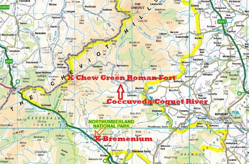
Agued for Agned is, however, much simpler to defend.  The W. agwedd is from a- + gwedd and meant 'appearance'.  Gwedd itself also meant 'appearance.'  If we go only a short distance up from Bremenium/Breguoin along Dere Street we come to the next Roman fort at Chew Green.  This fort is on the River Coquet, called anciently Coccuveda.  The word is preserved in W. as cochwedd, 'red appearance', a reference to the red porphyritic detritus washed down from the Cheviots.  

I am, therefore, going to propose that Agned is Agwedd, and that this was a reference to the Coch-[g]wedd Roman fort.

The process could have come about thusly: the Coccu-/Coch- element was at some point wrongly taken for English cocc, 'hillock', which yielded the monte of the HB.  It was then a simple matter, over time, to add a- to gwedd to produce Agwedd, Agued, Agned.

To be honest, I am more than a bit embarrassed that I did not see this before.  But place-names are notoriously difficult to deal with, and I hope my readers will forgive me my aimless wanderings.  Think of this as more of an adventure than a quest!

NOTE:  If we go simply by the MSS. variants for this place-name, we see that it was combined with Breguoin.  That may be an error, an attempt to reconcile the appearance of one of the other name in different MSS.  However, if it reflects actual tradition, then I would again mention my first idea for Agned, i.e. it represents the name of the Roman governor who rebuilt the Bremenium fort - EGNATIUS.  This has been allowed by the Celtic linguists, even if it does not superficially appear to be a perfect solution to the problem. 

I have written to Professor Dr. Peter Schrijver about Agned being from EGNAT and will report back here on what he has to say.

I do not think we can support any longer the notion that Agned is for Latin agnetis.  That is certainly what Geoffrey of Monmouth thought, as Agnes the virgin saint led him to look for a Maiden Castle.  See 

Sunday, April 2, 2023

Agned, Agnetis and Bremenium/High Rochester?


NOTE:  Since writing this piece, I have had time to consider whether I think it reasonable that Agned would merely be a W. rendering of L. Agnetis.  To be honest, I now think this unlikely.  And, in fact, looking at Agned as it serves in some MSS. as a substitute for Bremenium/High Rochester, I now believe I can offer a much better alternative origin for the place-name.  Something which I will attend to in a future blog post...

RIB 1267. Altar dedicated to Minerva at Bremenium/High Rochester

I have long rested content with my identification of Arthur.s Mt. Agned battle site with that of Breguoin/Bremenium/High Rochester, Northumberland.  I had made the identification thusly:

<Well, as it happens there another very exciting candidate for Agned available to us. A Roman inscription was found at Bremenium/High Rochester with the word EGNAT clearly carved upon it.  The full reading of this stone is as follows (from http://romaninscriptionsofbritain.org/inscriptions/1262):

“To the Genius of our Lord and of the standards of the First Cohort of Vardulli and of the Unit of Scouts of Bremenium, styled Gordianus, Egnatius Lucilianus, emperor's propraetorian legate, (set this up) under the charge of Cassius Sabinianus, tribune.”

This Egnatius was the governor of Britannia Inferior, i.e. Northern Britain, and as such would have been based at York.  He is known from another stone as well, found at Lanchester (http://romaninscriptionsofbritain.org/inscriptions/1091):

“The Emperor Caesar Marcus Antonius Gordianus Pius Felix Augustus erected from ground-level this bath-building with basilica through the agency of Egnatius Lucilianus, emperor's propraetorian legate, under the charge of Marcus Aurelius Quirinus, prefect of the First Cohort of Lingonians, styled Gordiana.”

There has been some speculation concerning this man, who may have been of very famous stock (see Inge Mennen’s “Power and Status in the Roman Empire, AD 193-284, note 79, p. 101).  In any case, as a governor and a rebuilder of forts, his name may have been become attached to that of Bremenium in a sort of nickname fashion – ‘the hill of Egnatius’ or, as it came down to us in the HB, Mount Agned.  Such a nickname may have been purely a local or even legendary development.  A good comparison to Bremenium as Egnatius’s hill would the Uxellodunum fort at Stanwix, called Petriana after its military garrison.

According to Dr. Simon Roday of the University of Wales,

“Agned cannot derive regularly from Egnatius, but I don't think it's impossible - as you say, there are examples of a- ~ e- in Welsh (agwyddor ~ egwyddor etc). Perhaps a sort of metathesis?”

The examples I had cited were merely a handful I had culled from some of the early Welsh poems:

engai, angai, engis, angwy, etc.

edewi, adaw, adawai, edewid

endewid, andaw

ail, eil

Doubtless more such instances of /a/ for /e/ could be found in other texts.

In answer to the criticism that the Egn- of Egnatius would have undergone a sound change to Ein- by the 9th century, Dr. Rodway added: "Old Welsh spelling was conservative in this respect, so it would be quite regular for the g to still be written.">

This seemed clever enough, but I have also felt it was a bit... strained.  For I knew with absolute certainty - having consulted the best of the Celtic linguists and place-name specialists - that the most regular etymology for Agned was a Welsh form of Latin Agnetis, the genitive form for St. Agnes.  Such an interpretation tied in nicely with Geoffrey of Monmouth's identification of the site with a Maiden Castle, as Agnes is the patron saint of virgins.

I thought little about at the time, for I was woefully ignorant about that particular saint’s VITA.  But here is the relevant abbreviated version of her Agnes' biography:

“Saint Agnes was twelve years old when she was led to the altar of Minerva at Rome and commanded to obey the persecuting laws of Diocletian by offering incense. In the midst of the idolatrous rites she raised her hands to Christ, her Spouse, and made the sign of the life-giving cross.”

Some good resources on Agnes and her relationship with Minerva:


Now, I had already proposed that the English Bathum in the guise of British Badon appears in the early Welsh sources precisely because for Aquae places featured the name of pagan goddesses.  In the case of Sulis at Bath in Somerset, the deity was associated with Roman Minerva - a virgin goddess.

This made me think of Roman period Minerva dedications in Britain.  When I went to RIB to look these up, I found the the site where the most Minerva inscriptions had survived WAS HIGH ROCHESTER.  It was also true that Minerva was worshipped at Carvoran on Hadrian's Wall, a place thought my most to derive from a Cumbric Caer + Forwyn (Morwyn), 'Fort of the Maiden', as the Roman Maiden Way road runs from Maiden Castle in Stainmore to Carvoran (https://romaninscriptionsofbritain.org/inscriptions/1267). 

Obviously, in the current context, the dedications to Minerva at High Rochester were the most interesting to me:

High Rochester -


My guess would be that Agned could be substituted in the HB battle list for Breguoin precisely because at some point Bremenium was thought of as the fort of Minerva, and given the objectionable nature of a pagan goddess presiding over the fort or over those men who had garrisoned the fort, the Christian name Agnes was substituted.  In this light, Bremenium at High Rochester could be 'Maiden Castle.'

I think it is important to remember that at Birrens the goddess Brigantia is identified iconographically with Minerva (https://romaninscriptionsofbritain.org/inscriptions/2091).  Brigantia was the tutelary goddess of the Brigantes. 

However, given that the only fort in the North that can be reasonably demonstrated to be a Fort of the Maiden in Cumbric, is Carvoran.  Maiden Castle in Stainmore, and the Maiden Way Roman road, would be English equivalents drawn upon by the name at Carvoran.  It might make more sense to allow Carvoran to be Agned, and for Breguoin to either be a separate Arthurian battle or (as many have suggested) an importation of the Brewyn battle of Urien of Rheged into the HB list.

A Hamian unit was stationed at Carvoran, and they worshipped the virgin Syrian goddess. According to Richmond (https://romaninscriptionsofbritain.org/inscriptions/1780, Commentary and Notes) this goddess was worshipped only by coh. I Hamiorum at Carvoran. At Carvoran, this goddess is literally called 'The Virgin.'  


RIB 1791: Poem in iambic senarii dedicated to Virgo Caelestis found in the NE of Carvoran. Imminet Leoni Virgo caeles/ti situ spicifera iusti in/ventrix urbium conditrix / ex quis muneribus nosse con/tigit deos: ergo eadem mater divum / Pax Virtus Ceres dea Syria / lance vitam et iura pensitans. / in caelo visum Syria sidus edi/dit Libyae colendum: inde / cuncti didicimus. / ita intellexit numine inductus / tuo Marcus Caecilius Do/natianus militans tribunus / in praefecto dono principis (The Virgin in her place in the heavens rides upon the Lion; bearer of corn, inventor of law, founder of cities, by whose gifts it is the good lot of men to know the gods: she is therefore the Mother of the gods, Peace, Virtue, Ceres, the Syrian Goddess, weighing life and laws in her balance. Syria has sent the constellation seen in the heavens to Libya to be worshipped: thence have we all learned. Marcus Caecilius Donatianus, serving as tribune in the post of prefect by the Emperor’s gift, led by thy godhead, has understood this). Source RIB I p.558.


"The priority for efforts to supervise the Wall curtain itself has received less attention, but one short stretch of the frontier zone in the central sector is identifiable as a consistent focus of activity and innovation: the gap between the Tipalt Burn and the Irthing (Symonds 2017, 39; Fig. 36). Prior to the establishment of Hadrian’s Wall, this stretch was supervised by the fort at Carvoran, and the fortlet at Throp. Further forts and a fortlet shadowed the Irthing as it flowed westwards, while towers were established on both sides of its valley. When work on the mural frontier commenced, the milecastles within the Tipalt-Irthing gap were probably among the first to be completed and manned, and at the very least turrets 48a and 48b are also likely to have been fast-tracked (Hill 1997, 42; Symonds 2005, 76; Graafstal 2012, 150). Construction of the Wall curtain also appears to have been accelerated, while the ditch was unusually substantial (Graafstal 2012, 145–146). Following the fort decision, turrets 44b and 45b – directly east of the eastern lip of this topographical bottleneck – became the most artfully positioned examples known on the Wall. To the west of the gap, where the northern lip of the Irthing valley lies hard to the south of the murus, a fort was established at Birdoswald. It is the milecastles along this strip, numbers 49–54, that appear to have been increased in size when they were rebuilt in stone."

Carvoran was also only a dozen miles east of Camboglanna/Castlesteads, Arthur's Camlann.


Friday, March 31, 2023

Why I Am Forsaking Dunipace for Bessingby as Arthur's Bassas

4/7/2023 UPDATE:

Working again with Brittonic language and place-name expert Alan James, I have settled on what is the simplest explanation for the various Bass names I have been considering.

Here is the decisive message from James on the subject:

"
The Bass Rock is certainly bathais 'brow, forehead, crown of head', which is exactly how it appears as you sail out of the Firth of Forth.

I can't find anything on Bass Hill Bwk, unfortunately the Glasgow U Bwk PNs Resource is unavailable just now. But I'd observe that Gaelic names are rare in Tweeddale downstream of Melrose, the toponymy is predominantly English, from early Ntbn to Modern. There are several 'Bas-' p-ns in England, that are referred to the common OE pers. n Bassa, including 3 '-lows' that were burial-mounds presumably repurposed when some of those Bassas were interred. Not so far away, Baskill in Ulpha Cmb is Bassa's shelf (ON skelfr)

If it were Gaelic, I think it would be another bathais. I don't the abstract noun bais is likely to be have been used in a hill-name, unless perhaps it held a gallows, or was the site of some carnage. People don't normally die in burial mounds or cemeteries, they're already dead when they get there! Something like *cnoc na mairbh 'of the dead' would be more likely.

The Bass of Inverurie (the motte) looks to me mightly like a bathais, just the same profile as the Bass Rock. 

My hunch for Dunipace is that if the generic, duine, is plural, the specific would still be singular, na bathais - like 'brow hills' in English, referring to a shared characteristic."

In my defense, I had thought of bathais before, but did not have access to supportive material.  I find the following in https://spns.org.uk/wp-content/uploads/2019/12/John-Reids-East-Stirlingshire-place-name-data-v2019.pdf:

"Mackenzie [SPN] believes that Bass, as in Bass Rock [and the Bass rock at Boddam], Bass of Inverurie, Bass Hill, Dryburgh, may derive from Gaelic bathais, forehead, which in topography may denote steepness."

Interestingly enough, that note in Reid's work is referring to a Bassie Moss (see the link for the above study) quite close to both Dunipace the town and the hills of Dunipace.  Bassie here is from G. basaidh, a basin, a suitable description for a boggy piece of land. This Bassie Moss contained a property called Arthur's Napkine (a pocket handkerchief or a neckerchief) or Gushet (a triangular piece of land, esp. one lying between two adjacent properties; a nook).  The napkine bit sounds like a bit of folklore, and it is possible the Arthur name appears here because of the Arthur's O'en at Stenhouse and/or because of the Myot Hill fort just west of Denny (as the Dalriadan Arthur died fighting the Miathi).  

Needless to say, a moss like Bassie is not a river, and we are still dealing with Gaelic place-names.  


It is probable, then, that Dunipace is a genuine Gaelic place-name and has nothing to do with Arthur’s Bassas river.  The best candidate for this last remains Bessingby Beck near Bridlington. 

4/6/2023 UPDATE:

I think that for the mounds at Dunipace we must look to those called the Bass and Little Bass of Inverurie for an understanding of the -pace element in the former place-name:

https://canmore.org.uk/site/18883/bass-of-inverurie

https://canmore.org.uk/site/18885/inverurie-keithhall-road-old-inverurie-churchyard

https://online.aberdeenshire.gov.uk/smrpub/master/detail.aspx?Authority=ASH&refno=NJ72SE0013

While the Bass and Little Bass were originally conjoined, the name seems to stand for the natural mound upon which a motte and bailey was built. As the Bass and Little Bass are in Aberdeenshire, we can safely say that the word in this context cannot be a British bas, ‘shallow.’

The Bass is in a cemetery now, and has had strong associations with death in folk tradition.

There is also a Bass Hill at Dryburgh in Scottish Borders.  This mound definitely has ‘death’ associations, as stone cists were found inside of it:

https://canmore.org.uk/site/55660/dryburgh-bass-hill

“Bass Hill: A natural mound. 'Druidical remains' have been found here.

Name Book 1857

Numerous interments of human bodies were found, all of them regularly placed, and many of them in Gaelic sarcophagi of four pieces of thin stone. In 1812 was found on the Bass a stone hatchet, among ashes. The site was probably a Bronze Age burial site.”

Even Bass Rock in the Firth of Forth might contain the Gaelic word for 'death', as it was the scene of many a shipwreck and much loss of life:

"Scotland’s south east coast is dominated by the estuary of the River Forth. The countries capital, Edinburgh, lies just to the south of the coastline and, as a result, the river has become a key artery for shipping bringing goods from all over the world to the population and industries of the city. The wide firth has many small islands across it’s breadth including May Island and Bass Rock that in poor visibility often caught unsuspecting or careless ship‘s captains unawares with tragic consequences. As the river narrows smaller islands like Inchkeith and Inchcolm further narrow the navigable channel and were often the site of further strandings and loss of life."


As Dunipace, The Bass and Bass Hill all seem to relate to beliefs about burial, I think the best etymology for Dunipace remains ‘Hill[s] of Death.’  As such, this site has nothing to do with Arthur’s Bassas.  Bessingby Beck remains our best candidate for the Bassas battle site.  

***

Dunipace Near Arthur's Oven in the Miathi Kingdom

Arthur's Oven Near Dunipace

Dunipace Showing the Ford (Bas)

For years now I have championed Dunipace in Scotland as Arthur's Bassas.  There were three reasons for the identification:

1) John Reid had settled on an etymology Dun-y-bais (see below) for the location.  As most linguists agree that Bassas is from bas, 'shallow' (and thus, in some contexts, a ford), this made sense.

2) Dunipace is near Arthur's Oven.  While the Roman monument had nothing to do with Arthur, it had been associated with him in folk tradition from fairly early on.  

3) Dunipace is in the territory of the Miathi, and we are told that Arthur son of Dalriada (NOT the earlier British Arthur) died fighting that Pictish tribe.

All of that seemed pretty good to me, even though it meant I had to allow for the Bassas battle being an intrusion into the list of a later Arthur.

For those who would like to learn more about Dunipace and Arthur's Oven, I refer you to the following helpful links:

https://spns.org.uk/wp-content/uploads/2019/12/John-Reids-East-Stirlingshire-place-name-data-v2019.pdf


John Reid, in The Place Names of Falkirk and East Stirlingshire 2009, 39-40, gives the most recent proposed etymology for Dunipace:

"‘The object of the name seems to have been two hillocks known as the Hills of Dunipace. These features nurutred another popular derivation: ‘hills of death’, dùnach and bàs. Certainly the hills may have been perceived as burial mounds, even today there are people who believe them to have been so, but, in reality, they are simply moraines. Historically the name exhibits only minor variations: 

Dunypais 1190, c1200 

Dunypas 1195, 1479 

Donypas 1207, 1470 

Dunpas 1251, 1267, 1426 

Donypace 1467, 1487 

Dunipace 1475, 1482 

From the late fifteenth century, with a few exceptions, it settles to the modern form. The name probably has origins in Cumbric and, given that the hills are next to an important ford, it may be acceptable to suggest the derivation *dun-y-bais (sic: should be *din-i-bas > *dyn-y-bas AJ, Reid’s version would be a Gaelicised form), ‘hill of the ford’ (more correctly, ‘of the shallow [place]’ AJ). It must be stressed, however, that Dun has a variety of meanings: ‘heap, hillock, hill, fort’ (but Cumbric din is definitely ‘a fort’, so ‘fort of the shallow’)."

To be honest, the old idea is better.  It doesn't matter if they were glacial moraines; people would not
have known that in the pre-scientific era.  They look like artificially produced grave mounds.

And I am very concerned with the use of a Cumbric bas here.  Used for a fording place, it is rare even in Welsh.  But look at this:

"The name of the road that ran north from the ford was “Rid Lonyng” or Red Loan which equates to the Redbraes found elsewhere in the Falkirk area that refer to early river crossings and which John Reid notes as having been derived from the British word “ritu” (Welsh “rhyd”) meaning ford."


If the Cumbric word rhyd was used for the ford in this context, why then employ bas?

I don't think Reid's idea works, alas. Dunipace should be Dunirid or Dunirit or some such, if it referred to the ford.  The extremely unusual form of the mounds would most certainly have suggested to people's minds ancient barrows.  Furthermore, as is all too obvious, a bas is not a stream.  We need a stream name that features bas[sas].  The river name at Dunipace is Carron, an ancient name that we find preserved as early as 710 A.D. in the Anglo-Saxon Chronicle.  'River of the bas', then, is not very convincing. 


For this reason, I have decided to reject Dunipace as Arthur's Bassas.  

Falling back on an earlier idea for Bassas, I naturally tend to gravitate to Dr. Graham Isaac's authoritative treatment of this name, which I cited in my various books.  Following his lead, I had appended some possible candidates, deriving Bassas not from a Cumbric bas, 'shallow', but from the OE personal name Bassa.  Here is the entire section from my original book on Arthur:

<The ending -as in Bassas would appear to have no explanation in either Latin or Welsh grammar. But it does have an explanation in Old English grammar. The name could thus be Old English. Just as Baschurch (Shropshire) is from Old English 'Basses cirice', i.e. 'Basse's church' (Eglwyseu Bassa in the Old Welsh poems), and Basford (Nottinghamshire) is Old English 'Basses ford', and Baslow Derbyshire) is Old English 'Basses hlaw', i.e. 'Basse's burial-mound'; so 'flumen quod uocatur Bassas' is easily unde stood as 'the river which is called Basse's', i.e. 'Basse's river'. There is a Basingbourne in Cambridgeshire, Old English Basingeburna, which is 'the stream of Basse's people', 'Basse's kin's stream'.

There are two genuine OE Bassa place-names further north in Northumberland. Bassington in
Cramlington parish was a farmstead a litte over a mile north-west of the village. It appears on a map of 1769 and is probably a much older site. In the present day town of Cramlington the site of Bassington Farm is on the Bassington Industrial Estate. However, other than this Bassington's proximity to the Devil's Water at Linnels (approximately 20 miles as the crow flies), there is little to recommend it as the site of Arthur's Bassas River battle. Most damaging, there is no stream here.

The other ‘tun of Bassa’s people’ is at the confluence of the Aln and the Shipley and Eglingham Burns not far east of a Roman road that connects Dere Street and the Devil’s Causeway. This Bassington is also roughly equidistant between the Northumberland Glen and the Devil’s Water/
Dubglas near Hadrian’s Wall, and near the Roman fort of Alauna on the Aln at Low Learchild.


The Streams at Bassington

Harehope Burn, near these hillforts -


- becomes Eglingham Burn, which joins the Shipley Burn and flows past Bassington.


Once again, however, there is no stream at Bassington bearing the Bassa name.

In the East Riding of Yorkshire, near Bridlington, there is a place I originally overlooked. This is Bessingby, the by or ‘farmstead, village, settlement’ of the people of Bassa. The important
thing about Bessingby is that there appears to have been a Romano- British settlement here
(http://www.pastscape.org.uk/hob.aspx?hob_id=1191551) and a Bessingby Beck or stream hard by.

"Summary : Air photographs show rectilinear ditches north and south of the railway and Bessingby Beck. Cropmarks of a multi-ditched enclosure with internal sub-division, also associated linear ditch boundaries, are visible. The enclosure measures circa 85 x 60m. Possible prehistoric or Roman date.

More information : Cropmarks of a multi-ditched enclosure with internal sub-division, also associated linear ditch boundaries, are visible on air photographs. The enclosure, centred at TA 1687 6556, measures approximately 85m by 60m. Possible Prehistoric or Roman date. (1-2)

APs show rectilinear ditches N and S of the railway and Bessingby Beck. (3)"

A Roman road ran from York to Bridlington
(https://roadsofromanbritain.org/gazetteer/yorkshire/rr810.html) and some believe (see Rivet and Smith) this to be the territory of the Gabrantovices, probably “cavalry fighters” and not “goat fighters”. The Gabrantovicum Sinus of Ptolemy would then be Bridlington Bay.

It is quite conceivable that Bessingby Beck was once known simply as “Bassa’s Stream”.

There is a potential problem with this placename, however. The –by terminal is Norse, and it is likely, therefore, that the entire name is not from Bassa, but from Bessi. Or, that if Bassa is the name recorded, it would not have become a place-name until fairly late. Here is what Alan James had to say on ths subject:

“A. H. Smith's PNERY, 100, which says: 'The first element may be a patronymic formation, "the people of Basa or Besa", but there is little or no evidence for such -inga- formations with OScand by. It is therefore more likely to be a patronymic Basing or Besing with an uninflected genitive. Each name is well recorded... the fo mer may be from OE Bassa or OScand Bassi, the latter from OScand Bessi (a variant of Bersi....).

As there is no clear evidence for a change of a to e in ME, Besing- seems more probable, and in that case the less frequent but earlier Basing- forms would be Anglo-Norman spelling variants... Besing's farmstead'.

Subsequent work, especially by Barrie Cox, has demonstrated that the patronymic '-inga-' formations in S and E England (as far north as Yorks) date from the pre-Christian period, so such formations would have been long since obsolete by the time OScand by was introduced.

Smith's etymology would imply an Anglo- Scandinavian formation from the late 9th - early
11th ct.”>

Eilert Ekwall (The Concise Oxford Dictionary of English Place-Names) has an interesting take on Bessingby:

"Basinghebi DB, Basingebi c. 1130 BM, Besingebi 1166 YCh 1139.  The form suggests an original Baesingabyr or the like. The first el. is apparently a derivative of the pers. n. discussed under BASING. But B~ is probably a Scandinavianized form of an OE Baesingaburh or -tun."

The English Place-Name Society site

"Basinghebi 1086 DB
Basingebi, Basingeby 1086 DB 1114–24,1135–9 Bridl 1128–32 BM
Besingbi, Besingby, Besyngby 1114–24 Bridl 1232 FF 1446 Ch
Basingby 1125–33,1145–53 Bridl
Besingebi, Besingeby 1155–7 YCh 1156–7 Bridl 1166 RBE 1195–8 P 1231,1246 Ass
Bessingby 1157–8 YCh1159
Bessynby 1521 Test
Besinby, Besinbie 1455 Test 1560 FF
Bessonby 1650 ParlSurv 1695 Morden

Etymology

The first element may be a patronymic formation 'the people of Basa or Besa ' (v. ing ), but there is little or no evidence for such -inga - formations with OScand  by. It is therefore more likely to be a patronymic Basing or Besing with an uninflected genitive. Each name is well recorded, Basing in LVD (ZEN 23) and Besing in the ERY Hernisius filius Besing (1142–54 YCh 1201) and elsewhere. The former may be from OE  Bassa or OScand  Bassi (ZEN 23), the latter from OScand  Bessi (a variant of Bersi , cf. LindN and Baswick supra 72). As there is no clear evidence for a change of a to e in Middle English, Besing - seems more probable and in that case the less frequent but earlier Basing - forms would be Anglo-Norman spelling variants (cf. IPN 112). 'Besing 's farmstead.'"

If we can allow for Bassa being present in this place-name, and given that we have both a beck bearing the name of Bass's people, and have a Roman road present that originates from Dere Street and is not far from York, Arthur's City of the Legion, I now feel fairly confident is putting this site forward as my new "improved" candidate for the Bassas River.

Yes, I know that many will object, if for no other reason than they refuse to allow English names into the HB battle list.  However, such Celtic language purists can be proven wrong again and again by English names showing up in the early Welsh heroic poetry.  A very good example that is especially pertinent in this case is the eglwysseu bassa or Baschurch that shows up as the grave site of Cynddylan.  Some have even opted to choose Baschurch as Arthur's Bassas - which is ridiculous, assuming we accept that he was fighting Saxons at the latter location. 


Roman Road from York to Bridlington 


Tuesday, March 28, 2023

A NEW IDENTIFICATION OF ARTHUR'S CASTELLUM GUINNION BATTLE

4/3/2023:

Dr. David Mason, the primary excavator of the Binchester Roman fort, has responded to my query at last.  As a result, I am more convinced than ever that Binchester/Vinovia is, indeed, Arthur's Castello Guinnion.

"Castellum or castrum/castra could have been used as terms for Binchester in that period, as earlier.

The latest of the two forts here was approximately 5.6 hectares or 14 acres in size and continued to be occupied in some form or another for about 600 years after Britain ceased to be part of the Roman Empire as evidenced by industrial and animal processing activities and a cemetery."

Dr David Mason FSA MCIfA
Principal Archaeologist
Archaeology Section
Environment & Design
Environment
Neighbourhoods & Climate Change
Durham County Council

3/31/2023:

A response from Professor Roger Tomlin on whether or not Binchester/Vinovia could have been referred to as a castellum:

"Yes, it [Binchester] could [be referred to as a castellum].   Modern writers use 'castra' of legionary fortresses, 'castellum' of auxiliary forts, which I would think reflects Roman usage. One of the Vindolanda tablets even refers to 'reditus castelli', the financial accounts of the 'fort'.  Binchester was an auxiliary fort, so no different in terms of its classification than Vindolanda.   I don't have the figures to hand, but the two forts would have been much the same size. Housing 500 men, as against the 5,000 of a legion."

As this is doubtless correct (although, I am still waiting to hear back from Dr. Mason, excavator of Binchester), there is now little reason not to accept Anscombe's plausible suggestion that Guinnion is an error for Guinuion, which makes for a perfect British rendering of the Vinovia Roman fort.  

3/31/2023 update:

Whitchester as Winchester on both Speed's and Blaeu's maps (1600s):

Blaeu

Speed

Whitchester and Arthur's Dubglas in Linnuis

3/30/2023 update:

I am asking Professor Roger Tomlin about the use of castellum. It seems to be used for a small fort, a fortlet, a watch-tower and the like - exactly like the mile castles we find on Hadrian's Wall. Which is why I like Whitchester/Wynecestre/Winchestr (Mile Castle No. 15) near Rudchester so much. It is not hard getting from a white fort (perhaps a borrowing of the Vindo- of the neighboring Vindobala/Rudchester) to the 'white people', i.e. the people of the white fort, the Vindiones. So stay tuned!

It is difficult to sustain the argument for Binchester as a castellum, regardless of its late period garrison.  And it seems unlikely that the castellum in the Historia Brittonum is to be interpreted as interchangeable with castrum.

In addition, I have taken the liberty of writing to the chief excavator of Binchester, Dr. David Mason.  I literally came out and asked him if he thought there was any possibility that Vinovia could have been classified as a castellum.  

Both responses will be posted here, and I will then proceed with further work on pinning down Arthur's Guinnion.

MOST RECENT UPDATE:

From 

Arthurian Names: Arthur
William A. Nitze
PMLA, Vol. 64, No. 3 (Jun., 1949), pp. 585-596 (12 pages)

"But, if following Anscombe we read Guinuion (that is, read u for n, since these letters are often confused), Jackson admits that "this could come from a Br. *Vinoviones ('the people of Vinovia').  Just what Jackson means by saying : "we have no right to alter it [Guinnion] for the sake of upholding an identification previously made on mistaken grounds," is not clear.  Are we to take no account of circumstantial evidence?"

I must side with Nitze on this point.  We need only look at all the other variant spellings for the HB battle-site names in the various MSS. I do not have a problem with Guinuion for Guinnion, honestly.  This allows for us to identify a people we know of from the historical record, and one who is within the orbit of the Northern Arthur, and in a place where he might have fought the Saxons at the time.  Opting for Carwinning in Ayrshire produces problems, and I am not comfortable choosing the site, as it would represent an extreme outlier when compared with all the other battle sites.  And besides Carwinning, there are no good alternatives.  My idea for Whitchester/Winchester mentioned below provides us only with the 'white' word, minus the important elements that follow it.  

For this reason, after much vacillation, I am going to stick with Binchester as Arthur's Guinnion.

I am also in agreement with Professor P.J.C. Field, who in Arthuriana, Vol. 18, No. 4, In Memoriam: Elisabeth Brewer, Derek Brewer (WINTER 2008), pp. 3-32 (30 pages)
https://www.jstor.org/stable/27870935, said that "The castellum [of the Guinnion entry] shows that this must have been a Roman fortified site, which limits the possibilities."  This sentiment is shared by all the top scholars who have taken a look at Guinnion.  An umpressive hillfort in the Lowland Scottish hinterland like Carwinning would not have qualified as a castellum.

Peter Verburgh (personal communication), who is quite knowledgeable when it comes to the Roman army, has informed me that

"The term "castellum" is equally interesting : in the Roman military nomenclatura this was specifically used to designate a fort which was occupied by Auxiliary troops , castrum/castra being preserved for forts with Legionary troops - the garrison of Binchester, especially the later smaller fort, housed precisely such a unit - and although in the later Roman army the distinction between auxiliary and legionary largely disappeared, perhaps the name was a remnant of a ( hypothetical ) "Castellum Vinoniensum" , or something similar."

And from the Roman military writer Vegetius: “And if no ancient fortifications are to be met with, small forts [castella] must be built in proper situations, surrounded with large ditches, for the reception of detachments of horse and foot, so that the convoys will be effectually protected. For an enemy will hardly venture far into a country where he knows his adversary’s troops are so disposed as to be ready to encompass him on all sides.”


John Koch has this on the Irish:

"The Old Irish word caisel ‘fort, castle, fortified settlement’ reflects a borrowing from Latin castellum. The change of Latin st to Irish s marks out caisel as an early loan (c. ad 500 or earlier). The word is thus suggestive regarding contacts between the early Irish and the Romans or Romanized Britons, probably specifically— given the meaning of the word—contacts in the military sphere."

CELTIC CULTURE:A HISTRORICAL ENCYCLOPEDIA

NOTE:

As I wrote this piece, I was going by what Alan James had just passed along to me about Rudchester near Whitchester on Hadrian's Wall:

"And Rudchester seems likely to have been red! I've not got the records for that name, but it does seem that, in OE eyes, the fort and the milecastle were red and white respectively. So why the Britons thought the fort was white but the Angles thought it was red is a puzzle!"

This does not agree with Ekwall (The Concise Oxford Dictionary of Place-Names), where Rudchester  (Rodecastre 1251, Rucestre 1256; the dates for Whitchester - see below - precede the dates for Rudchester) is said to derive from 'Rudda's ceaster', Rudda being a personal name!

This appears to be the consensus view on this place-name, as The English Place-Name Society site at http://kepn.nottingham.ac.uk/map/place/Northumberland/Rudchester has:

Rudchester
'Rudda's Roman site'.

Elements and their meanings
pers.n. (Old English) pers.n. Personal name
ceaster (Old English) A city; an old fortification; a Roman site.

If these sources are correct, then Whitcastle as a Win- castellum could still owe its name to Vindobala.

I will, in James' defense, remind my readers of this:

"Rudchester means 'Red Camp' and there is a reason for its name. It stands, in fact, upon the site of Vindobala, one of the Wall forts, and when in 1924 part of that fort was excavated it was found that many stones had been turned red by burning. Here was evidence of a tragedy long before the first of the Rudchesters built his tower out of the ruins."


When I discussed that view with James, he replied:

"Mind, the info on the KEPN site isn't necessarily 'recent', in this case it's simply following Ekwall, as there's been no full survey of Ntb (and it seems Mawer didn't include Rudchester). The name Rudda is in the Durham Liber Vitae, Ruddington Notts, and possibly elsewhere. But I was mistaken in thinking of OE ruda as an adjective, it's a noun 'redness', the adj. is rudig 'ruddy'

There's also a Ruchester Farm on the Military Road, in Chollerton parish, which Smith (probably following Mawer) sees as OE ruh- 'rough'; I can't find the exact location, but it must be some way to the west of Rudchester, and only accidentally (and confusingly!) similar.

The only authority given for the assertion about burnt stones being red is Paul Brown's Friday Books of North Country Sketches (a selection of 'Friday Articles' from the 'Newcastle Journal' published from 1934)', not I think a very weighty one, and Mr. Brown evidently made the same mistake as I did. Ekwall gives Rodecastre 1251 (also Rucestre 1256, but I wonder if that might be Ruchester, see my previous message). I'm not entirely convinced that it's the pers. n. Rudda, but it's not likely to be 'red'."

It is possible, then, a white fort name became red only very recently, when the burned stones were discovered and the name applied.  However, Wincestr for Whitchester may show an earlier relic, one preserving the Vindo- of Vindobala.  If this is the case, then the site would make for a splendid Guinnion, in Jackson's terms a fort of the 'White People' (Vindiones). 

I will be working on this idea and alter this blog post accordingly, if I think doing so is desirable or necessary. 


Carwinning Hillfort

Carwinning Hillfort 


For many years now, I have accepted that Binchester was Arthur's Guinnion.  However, as we now possess inscriptions showing the Vinovia spelling of the place, we can no longer fall back on the convenient argument presented in Rivet and Smith's THE PLACE-NAMES OF ROMAN BRITAIN:

"Note (3). A further interesting survival is discussed by O. G. S. Crawford in Antiquity, IX (1935), 287. Arthur's eighth battle was fought, according to Nennius (56), in castello Guinnion. Crawford notes that objection had been made to the identification of this with Vinovia on phonetic grounds, rightly; but Crawford seems not to have noted that Ptolemy's alternative Vinnovium (British *Uinnouion) brings us very close to the later name set down by Nennius. There is still a problem, however, in that Vinnovium should have given in Old Welsh at this stage a form in -wy, or similar; but it could be that -ion has been maintained as a learned form. Crawford, even without this support, thought that theidentification should not be entitrely rejected, and he was surely right (Holder III, 354 supported the equation too)."

Kenneth Jackson appears to have been right when (in his 'Once Again Arthur's Battles') he said:

"Actually OW. Guinnion would come from a British *Vindion- or *Vinnion-; probably the former, as it contains the known stem *vindo-, 'white whereas there is no known Br. *vinn-. It might stand for Br. *Vindiones, 'The White People,' something like *Dunon Vindionon = Castellum Alborum; the MW. plural of gwynn, 'white' (Br. *vindos) was gwynnion, from OW. guinnion, Br. *vindiones. This cannot be Binchester."

We cannot justify opting for a form in Ptolemy, as the name would certainly have come not from that source, but from a tradition known to the early medieval Welsh.  In other words, Guinnion comes from a place-name they were familiar with, not from a Greek text.  

Alan James, noted expert on Brittonic place-names in the North, told me that

"Crawford and Holder pre-date Jackson's LHEB, and though R&S were a generation later, they paid inadequate attention to his treatment of the loss of terminations. And Sims-Williams since has confirmed Jackson's finding, there is no evidence whatever for such final syllables being 'maintained as a learned form', they were gone by mid-6th ct."

But if not Binchester, then where is C. Guinnion?  Certainly, in the North, as all the surrounding battle site names are situated firmly in that region.

Well, we could opt for White Castle hillfort in East Lothian, or even Whitley Castle Roman fort in Cumbria.  Both of these sites would fit the range of Arthurian battles, although, admittedly, Whitley Castle is awfully far west.  And there are other 'white' hillfort names in Northumberland and Lowland Scotland, e.g. Whistcastle Hill, White Meldon,  Whiteside Hill. A good example of one on Hadrian's Wall is Milecastle 14 at Whitchester, Witcestre 1221, Whitcestr 1244 (Ekwall), which was (according to Camden; see https://www.lakesguides.co.uk/html/LakesTxt/cam2p219.htm, https://www.visionofbritain.org.uk/place/9774/names, http://kepn.nottingham.ac.uk/map/place/Northumberland/Whitchester and p. 40 in https://trepo.tuni.fi/bitstream/handle/10024/78311/gradu02047.pdf?sequence=1) once called Winchester, perhaps having been influenced by the nearby Rudchester Roman fort, Vindobala.

"Beyond the Wall rises the river Pont; and running down by Fenwick-hall, the seat of the eminent and valiant family of the Fenwicks,* for some miles fronts the Wall, and had its banks guarded by the first Co∣hort of the Cornavii at Pons Aelii,* built by [the Em∣perour] Aelius Hadrianus, and now called Pont-Eland.* Here Henry the third concluded a peace with the King of Scots, in the year 1244. and near it the first Cohort of the Tungri lay at Borwick,* which the Notitia Provinciarum calls Borcovicus.* From Port-gate the Wall runs to Waltown, which (from the agreeableness of the name, and its twelve miles di∣stance from the eastern sea) I take to be the same Royal Borough which Bede calls Ad murum;* where Segebert, King of the East-Saxons was baptiz'd into the Christian Church byoPaulinus. Near this is a Fort call'd Old Winchester,* which I readily believe to be Vindolana;* where, as the Liber Notitiarum says, the fourth Cohort of the Galli kept a Frontier-garrison. Thence we went to Routchester, where we met with evident remains of a square Camp joyning close to the Wall. Near this is Headon, which was part of the Barony of Hugh de Bolebec; who, by the mother,* was descended from the noble Barons of Mont-Fichet, and had no other issue than daughters, marry'd to Ralph Lord Greistock, J. Lovell, Huntercomb, and Corbet."


Page 20 of this source - 


- has more to say on Whitchester as Winchester:

"The earthwork which gave its name to Whitchester (or Winchester as it is called by Camden, in Speed's and other early maps, and occasionally in documents)... Winchester is certainly Whitchester... For the form Wynecestre see Northumberland Assize R. (S.S. Vol. lxxxviii.) P. 171."


The problem with all of them is, of course, their English names.  We can never prove that Guinnion underlies such. Badon is an exception to the norm, as the English name for this last was chosen as a substitute for the markedly pagan name from the Roman period (Aquae Arnemetiae). We are not justified in seeing in Guinnion a Welsh translation of an English 'white' place-name. 

As Alan James puts it, 

"The fact that somewhere called Vindo- in early Brittonic might have been called Hwit- in OE is not very persuasive, both words were used pretty commonly for a wide variety of relatively light-coloured features."

There is, fortunately, a good alternative for Guinnion - one I considered and dispensed with years ago because I was unaware of the location's connection with the Virgin Mary.  I am referring to Carwinning in Ayrshire. [1]

Alan James (https://spns.org.uk/wp-content/uploads/2019/03/Alan_James_Brittonic_Language_in_the_Old_North_BLITON_Volume_II_Dictionary_2019_Edition.pdf) has this on Carwinning:

Carwinning Ayrs (Dalry) CPNS p. 366 + personal, presumably saint’s, name -Winnian; cf.
Balfunning under bod, and note that Kilwinning Ayrs is adjacent.

We know that the Guinnion battle is the one in which Arthur carried the image of St. Mary on his shield.  This is interesting, as 

"Kilwinning was a Tironensian Benedictine monastic community, named after Tiron in the diocese of Chartres. The abbey was dedicated to Saint Winning and the Virgin Mary, and founded sometime between 1162 and 1188 with monks coming from Kelso."


The site is listed with good information at 


"KILWINNING
Kilwinyn 1202, Pais. Reg.

Kylwynnyn 1315, RMS

Kylwynin 1320, RRS v

Kylvynnyne 1357, RMS

Kylwenyne 1426, Dryb. Lib.


SAINTS IN THIS PLACE-NAME
Findbarr, Bairrfind, Bairre, Uinniau, Finnén etc (ns) (certain)

Finnian m. Cairpre of Moville (probable)

Finnian m. Findloga of Clonard (probable)

Bairre m. Amairgin of Cork (maybe)


RELATIONSHIPS WITH OTHER PLACE NAMES
Is source of Kilwinning, Kilwinning, parish

MONASTERIUM SANCTAE MARIAE ET SANCTI WYNNYNI
monasterio Marie Sancte et Sancti Wynnyni 1364, RMS


SAINTS IN THIS PLACE-NAME
Mary, Mary the Blessed Virgin, Our Lady (ns) (certain)

Mary the Blessed Virgin (certain)

Findbarr, Bairrfind, Bairre, Uinniau, Finnén etc (ns) (certain)

Finnian m. Cairpre of Moville (probable)

Finnian m. Findloga of Clonard (probable)

Bairre m. Amairgin of Cork (maybe)

NOTES
This is the site of a Tironensian abbbey, founded in the twelfth century. But the name, coined with Gaelic 'cill', suggests that the abbey was built on an earlier ecclesiastical site. NMRS records the present thirteenth-century remains, destroyed shortly after the Reformation, and partially repaired for use as a parish kirk until 1775. Various other rebuilds and restorations have taken place since.


While the St. Mary foundation date is late, it is widely believed the bit about Mary at Guinnion is a later gloss.  

Even better, there was a hillfort at Carwinning:


"Carwinning fort occupies a splendid situation, 658ft OD, on the W side of the valley of the Pitcon Burn, the flank of which is here particularly steep. Now much wasted, it consists of a central enclosure about 300ft in diameter, lying within the remains of an outer wall some 100ft away. A small central enclosure, about 100ft in diameter, formed by a stony mound, could be intrusive and might represent the robbed remains of a dun (R W Feachem 1963).

D Christison 1893

This fort, situated on a promontory with steep natural slopes on the N, E and S, consists of a vague central mound about 30.0m in diameter, surrounded by the remains of a much spread, grass-covered, stone wall 3.0m wide and 0.5m high were best preserved, and about 65.0m in diameter. On the W of the fort, varying between 34.0m and 40.0m from the inner wall, is a further wall 3.0m wide, with a maximum height of 1.2m ending on the natural slopes to N and S. For part of its length this wall is surmounted by a field wall. Running from the centre of the fort to the E slopes is a modern field bank 3.0m wide and 1.0m high. Quarrying has been started on the E face of the hill.

Though the NSA (1845) asserts that traces of a ditch may be seen at the foot of the hill, nothing was noted during investigation.

Visited by OS (DS) 4 September 1956

This fort is generally as described in the previous field report; the ramparts are now no more than 0.5m high, while the central mound is too denuded to be accurately surveyed. The quarrying mentioned above appears to have been abandoned.

Surveyed at 1:2500.

Visited by OS (JTT) 28 October 1964

The site of this robbed fort is being excavated in advance of quarrying. Excavation of several areas totalling some 1250 square metres showed (a) the central area, about 30.0m. in diameter (A on sketch plan by OS (DS) proved to be several cairns. One of these cairns consisted of a low mound of angular rubble enclosed by a badly robbed rubble kerb, covering a collared urn, a bronze chisel (?) and half a stone battle-axe, reused as a hammer. Overlying the N cairn is a wall of massive boulders, which may be part of a defensive enclosure on the hilltop. (b). The ramparts are all severely robbed and their construction is unclear. (c). In the interior of enclosure 'B', stone-packed post holes have been located, but no trace of their associated floor has survived. (d). The whole of the outer earthwork (c) appears to be a relatively recent field dyke and its apparent ditch proved to be a shallow scrape for bedrock.

T Cowie 1977.

Further work in 1978 showed that on the summit of the hill the remains of a single low Bronze Age cairn are overlain by the footings of a boulder wall, apparently associated with a posthole lined entrance, but no further evidence has emerged for the date of these features. The construction of the main defensive enclosure was clarified: a palisade slot embanked with rubble and/or soil appears to have existed in place of or replacing the palisade. Within the enclosure, but not certainly associated with the palisade, excavation revealed the stone-packed postholes of a porched circular structure, and in the same area traces of post-Medieval occupation. Along the course of what was superficially taken to be a robbed enclosure wall, were located the remains of a series of very shallow but severely eroded interrupted depression, up to 7m by 2m in extent but no more than 0.2m deep. In the subsoil, on their interior, was a series of shallow postholes running along the line of the low bank of upcast material and stone.

T Cowie 1978

Photographed from the air.

D A Edwards and E A Horne 1978

A further phase of quarrying operations has destroyed the NE part of this fort, and much of the interior detail established by excavation to be archaeological features. Only a roughly circular segment of this interior detail, some 0.4m high, survives, and this has no recognisable form. The enclosure works around the hill, visibly indicating more than one phase of activity, survive as described on the W and S. At the time of investigation active quarrying had once more ceased.

Revised at 1:2500.

Visited by OS (JRL) 28 February 1983.

The battle-axe is a grooved example of the Intermediate-Developed form. It is held in Glasgow Art Gallery and Museum, and has been petrologically attributed to group XXVIII (quartz dolerite from various sources in Scotland and Northern England).

T H McK Clough and W A Cummins 1988."

Now, it is true that a British Arthur of the 5th-6th centuries A.D. would not be fighting the invading English at Carwinning.  But if Carwinning is the right site, we may have another intrusion into the battle-list of a place where the Dalriadan Arthur fought.  I have suggested that Bassas, if Dunipace, was also a Dalriadan Arthur battle, as the Hill/Fort of the Shallow is between the two Miathi forts, and Arthur son of Aedan is said to have fallen fighting the Miathi.  The Finnian in question at Kilwinning may be the saint under whom St. Columba studied.  Columba was a contemporary of Arthur son of Aedan. 

Alan James commented thusly on the idea that Guinnion could be Carwinning:

"Carwinning is an interesting possibility, not too difficult to derive from *cair-winnion. Winnian is identified by many scholars with the Vennianus who corresponded with Gildas, and also with Finnian of Moville (at the head of the Ards peninsula in Co Down, within sight of the Rhinns and easy sailing distance from Irvine) who in turn is identified as the tutor of Columba. And Thomas Owen Clancy has even proposed that he might also be the 'real' Ninian of Whithorn. If the Gildas and Columba links are valid, he would have lived in the early 6th century, he'd have been quite well-known in the time of HB, early 9th, so the place-name might have existed by then."

But might we salvage Carwinning for Arthur son of Sawyl of Ribchester?  As it happens, yes, we can, if we are willing to allow for a battle against an enemy other than the English.  Sawyl had married a daughter of a famous king of the Dal Fiatach, and the Dal Fiatach held the Ards peninsula mentioned by James in the context of Finnian of Moville.  We might see in the Castello Guinnion battle an action on the Dal Fiatach's part against Strathclyde - an action in which Arthur took part. Granted, this is a bit of a stretch, but it is not at all impossible. 


[1]

Andrew Breeze in https://sciendo.com/pdf/10.1515/scp-2016-0001 says the following about Guinnion:

"The fort of Guinnion will not (as this writer previously thought) have been at Kirkgunzeon, near Dumfries in south-west Scotland; it was surely (as proposed by Tim Clarkson of Manchester) Carwinning, a minor defence three kilometres west-south-west of Kilbirnie, in south-west Scotland."

Note:  there is no fort at Kirkgunzeon.  The Corra Castle found there is of 17th century date.

I've not been able to track down when Clarkson made this identification.  I show an independent online publication of the idea (albeit rejected in the context) dated THURSDAY, JULY 28, 2016 (https://mistshadows.blogspot.com/2016/07/the-arthur-of-history-chapter-three.html).  The book containing that identification had been published sometime before the blog post.  

Hence, I am not sure who should be given precedence as the originator.  I have written to Dr. Clarkson and will supply the missing information here as soon as I manage to obtain it. 

3/28/2023 - I received Dr. Clarkson's response:

"Nothing has been published yet on my Carwinning theory. Andrew Breeze is the first person to know about it and has cited it a couple of times. I first mentioned it to him a few years ago during an email conversation about locating Arthur's battles in South West Scotland. This is as far as I've gone with the theory. At one point I did consider putting it up on my blog but my entire blogging activity has been mothballed for a while."