
Durocornovium and the Roman Roads (Courtesy https://sashamaps.net/docs/maps/roman-roads-of-britain/)
Quite a long time ago I entertained the idea - not very seriously - that Arthur's Cernyw or Cornwall could be a reflection of Durocornovium, a site literally right next to both Barbury Castle and Liddington Castle/Badbury (one of the candidates for Arthur's Badon).
But now that I am quite certain that Illtud = Uther, and given that no other father for the legendary Arthur other than Uther has been put forward by the Welsh tradition, and given that Illtud was born in the 'Llydaw' that is actually the Leadon Vale, part of the old Dobunni kingdom, and given that the old Dobunni kingdom included Durocornovium, Barbury Castle and Liddington Castle, I must reconsider that which I once dispensed with, i.e. Arthur was operating militarily in the region that included Durocornovium. And that means that the traditional assignment of Arthur to Cornwall/Cernyw may be a folkloristic relocation of Durocornovium.
To my mind, the only real question at this point is what does Durocornovium actually mean. It it this question to which I will address myself for the remainder of this blog post.
There are, essentially, two theories regarding Durocornovium. One is that a group of the Welsh Cornovii tribe were settled at the new Roman city or that they may have been a garrison at a fort there. The other has the name be purely local, perhaps for a geological feature, such as a horn-shaped extension of higher land. Certainly, a case could be made for this last, given the topography of the region.
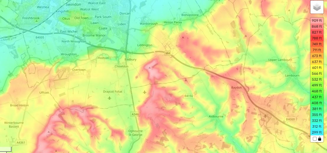


Topo Maps of Liddington and Wanborough (Courtesy https://en-us.topographic-map.com/map-dvs7tf/Wiltshire/?zoom=13¢er=51.52263%2C-1.68503)
My guess for the "horn" would be the situation of Upper Wanborough, which lies between Nythe Farm and Liddington Castle. From http://www.british-history.ac.uk/vch/wilts/vol9/pp174-186:
"Geographically the parish is divided roughly in half, the southern section lying on the chalk downs. The shape of the parish conforms to a pattern found along the scarp slope of the Chalk both westwards into Wiltshire and eastwards into Berkshire, each parish having chalk uplands as well as greensands and clays for meadow and pasture. (fn. 7) Upper Wanborough, around the church, is on an Upper Greensand spur [emphasis mine] commanding a view north over Lower Wanborough and south over Liddington. The northern half of the parish towards the shallow valley of the River Cole is successively Gault, Lower Greensand, and Kimmeridge Clay. (fn. 8) The chalk scarp rises behind the village, reaching 800 ft. at Foxhill on the parish boundary. Most of the Chalk lies between 600 ft. and 700 ft. Two coombs pierce the eastern boundary between the Ridge Way and the Icknield Way, the larger containing two chalk pits. Below the scarp the land falls gently away to the river, to below 300 ft., and is drained by the Cole, its tributary stream the Lidd [for which Liddington was named], and several smaller streams, providing abundant meadow land and marsh. There is little wood in the parish, although there is evidence of illegal felling during the 16th century. (fn. 9) Stone was quarried at Berrycombe in the 16th century (fn. 10) and marl was taken from Inlands at least from the end of the 13th century. (fn. 11)"
A spur of land or a section jutting out between two coombs could be construed as a "horn of land" and so Cornovium may have been used here in the same sense as it was for Cornwall (Cernyw), which was a horn of land jutting out into the sea.
I am posting here some nice selections from Rivet and Smith (THE PLACE-NAMES OF ROMAN BRITAIN) and other respectable sources on the Durocornovium place-name, and the Cornovii tribal designation in general.
"Note. The two names Durocornovium (qq.v.) indicate the presence of Cornovii also in Cornwall and Wiltshire. In Cornwall (to which they ultimately gave its name) they were presumably either a subdivision or a client-tribe of the Dumnonii and the appearance of the place-name in Ravenna suggests that they were there before any supposed migration from the Shropshire area in the fifth century (e.g. J. Morris, The Age of Arthur (London, 1973), 68-69). The name in Wiltshire is unexplained, but it might represent a group who settled there in the course of an early migration or the early garrison of a fort."
There were other Cornovii in Britain, including a group in the extreme north of Scotland:
"The base of these names is British *corn- 'horn' (Welsh and Irish corn; Latin cornu) and it has been suggested (Watson CPNS 16) that the British peoples were so called because they lived on 'horns' of land, promontories. In the case of Cornwall C. Thomas (Rural settlement in roman Britain (London, 1966), 86) has plausibly argued that the Cornovii there, as Venetic immigrants, might have been given the name by the Dumnonii because they dwelt in promontory forts (cliff-castles), but in Cheschire (where the wirral peninsula would be involved) and in Caithness to interpret the name geographically is probably to use the perception of moderns accustomed to looking at maps. For the people of Shrophire and Cheshire the vertical 'horn' of the Wrekin might conceivably be invoked, but this would not explain those of Caithness. Ross( 1967) 143 thinks that peoples do not neme themselves in this way and that the Cornovii are rather 'worshippers of a horned deity of the Cernunnos (stag-god) type', which is surely preferable.
IDENTIFICATION. A people of Scotland, placed furthest 'east' (i.e. north-east) by Ptolemy and so to be locatcd in Caithness."
Most authorities do hold to the Cornovii of Durocornovium being a tribal designation, although one possibly based on a local geographical feature:
"The Roman town of Durocornovium was located at Covingham, the junction of two Roman roads, the Ermin Way and the road south to Mildenhall (Cunetio). The Ermin Way connected London via Silchester ( Calleva Atrebatum ) to Cirencester ( Corinium Dobunnorum ), the second largest Roman town after London.
Durocornovium was founded in the First Century as a military camp but it became a merchant town covering more than sixty acres & having a population of several thousand at its peak in 350AD.
Duro is a Celtic word meaning "door" or "enclosed market, square, forum, walled town, village"
Cornovium may either be a common noun in Brittonic meaning "horn, peninsula", or derive from the British Cornovii people of the Midlands , based around Wroxeter ; alternately, we may have or an identically-named tribe from the area of Durocornovium."
To date, no archaeological evidence for a Dark Age battle has been found at Liddington Castle near Durocornovium. I have been given an important recent paper on the subject from Professor Richard Bradley and am offering the Conclusions section of that study below:
"Archaeol.J., 153 (1996), 1-59
Liddington Castle and the Battle of Badon:
Excavations and Research 1976
By SUSAN HIRST and PHILIP RAHTZ
with contributions by EMMA ASHTON, RICHARD BRADLEY, HuGH CARTER,
]. D. R. DAVIES, JULIE GARDINER, JENNY STEVENS, and ROBIN TAYLOR:
CONCLUSIONS
The 1976 excavation showed that Liddington Casde is rich in data, especially for the
Late Bronze Age/Early Iron Age period, possibly beginning as early as the seventh
century B.C. Pottery, bone and metal were well-preserved, and prolific in the very
small areas explored.
The Neolithic and Early-Middle Bronze Age are represented only by earlier finds,
within and outside the area of the Casde; there is also a long barrow in the vicinity.
There is nothing from the I 976 excavation which is likely to be earlier than the Late
Bronze Age (unless the shaft found in Cutting B is ofNeolithic or Bronze Age date).
The sequence defmed in the stratification of the rampart, in the single area
examined, is divided in this report into four phases; these may represent four successive
stages of rampart construction, or may be interpreted as a primary structure in two
sub-phases revetted at its rear with timber and chalk, enlarged later by a single dump
rampart associated with a ditch; possibly with a chalk block facing, and a slight rear
chalk revetment.
The rampart layers of our phases 1-3 (Illus. 12) are associated with pottery dated by
Professor Bradley to the Late Bronze Age/Earliest Iron Age; an associated copper alloy
pin is dated by Robin Taylor to the seventh-sixth centuries B.c. Bradley suggests that
on the basis of these finds Liddington Casde was among the earliest hillforts in
Wiltshire, one of a significant number of hill-top sites to be defended at this time. The
attributes of this group include the construction of timber-revetted ramparts and
ditches. The results tie-in with other sites in the area such as Uffington Casde, Ram's
Hill, and Ivinghoe Beacon, in suggesting that such developments occurred significandy
earlier along the North Wessex downs and the Chilterns than in the classic hillfort
zone of southern Wessex, characterized by Danebury (Cunliffe and Poole, I99I).
The external referee for this paper points out, however, that the pottery in the
rampart is not necessarily associated with its construction, providing only a terminus
post quem. The pottery may date our phase I, but phases 2-4 (the dump rampart) may
be substantially later, perhaps as late as the fifth-fourth centuries B.C. (cf. our pottery
of Group 3), but fairly soon abandoned. The whole dating and construction should,
the referee suggests, be viewed in the wider context of the Wessex sequence
(cf. Cunliffe and Poole I991, 3.6 for Danebury; and Cunliffe I991, ch. 14 for a more
general discussion).
The evidence for the defences was in the cuttings at the west end of the hillfort. At
the east end, the causeway across the ditch was shown to have been an original feature.
Behind the rampart were occupation levels, possible timber structures, and at least one
shallow pit, perhaps an emplacement for a barrel or a tank; a deeper hole close by was
not bottomed, but appears to have been of considerable depth, perhaps a 'ritual shaft',
well, or even a flint mine (of pre-Iron Age date).
The cultural material of the Late Bronze Age/Early Iron Age consists of nearly a
thousand sherds of pottery, classified in three groups; I I I possible slingstones, ferrous
slag and haematite ore; 86 flints (probably of the earlier phases); objects of iron and
copper alloy; a few human bones; and nearly a thousand animal bones of nine species,
among which cattle, sheep/ goat and pig were dominant; and a piece of possibly
utilized bone. While most of this material was found in the principal westerly cuttings,
a similar assemblage came from a small cutting behind the rampart on the south side.
The possible slingstones occurred only in contexts associated with pottery of
Groups 2-3; none was found in Group I contexts. This suggests that this method of
attack or defence if such it was, was not one current when the hillfort was first
constructed, but came into use at a later stage, in the Early Iron Age.
The haematite ore could have been used for iron smelting, but no slag was found
with it; this material was however widely used in this period for colouring pottery
(haematite ware) either as a slip, or applied as a surface colouring; this is perhaps its
function here, or for other 'reddening' purposes, such as cosmetics or colouring
medicine.
The human bones (all certainly or probably male) could be from disturbed burials,
but it is more likely that they derive from unburied victims of violence, ritual
activities, or cannibalism.
The animal bones probably reflect hunting/stock-raising/ eating patterns among
the population; but this should not be taken as proven; other explanations for the
proportions of species are possible. The red deer specimens could for instance be from
hunting, or the result of the natural death of animals inside or outside the hillfort. The
horses could have been for riding, and the dogs for domestic or hunting use.
There is little evidence from the excavations for occupation in the Roman or dark
age periods. Such Roman material as was found is all from the east end, in the ditch
terminals: a sherd of samian ware, a counter probably also made from samian ware,
and two other undiagnostic sherds. The low stratigraphic position of these does
however suggest that the ditch terminals on either side of the causeway of the eastern
entrance had been cleaned out in Roman times. Roman pottery has indeed been found
inside the hillfort, and at several places in the immediate vicinity (Illus. 2). There are
also some pieces of limestone and sandstone, probably from a fairly distant source,
which may be parts of Roman roof slates.
It may be that excavations nearer the east end would have yielded more evidence of
Roman occupation or subsequent re-use of the hill-top than we found at the west end.
Agricultural use is to be expected, and there is always the possibility of a late Roman
hill-top temple. It should be noted however, that the putative evidence for this-a
bronze figurine of Cupid-attributed by Green (I976, I92) to the Castle, is in fact
from Avebury.
There is however no archaeological evidence from the site, past or present, that
would support its identification with Mount Badon; the arguments for Badon being
here, on topographical or other grounds, remain, and as we stressed in our
introduction, the character of dark age warfare, and of the recorded circumstances of
this confrontation in particular, are not such that archaeological evidence is likely to
be found.
The next use of the hill-top that can be inferred from the finds in the excavation
was in the medieval period, perhaps as early as the eleventh century, depending on the
dating of the pottery. While the pottery could derive from military occupation, in
local or national power struggles, it is most likely the result of agricultural or pastoral
use of the hill, with or without transient or pennanent structures.
The post-medieval and modem finds could be similarly explained, but since the
eighteenth century at least one has to add the attractions of the hilltop to hunters, clay
pigeon shooters, smokers, picnickers, and walkers: all of whom left evidence for their
visits.
To conclude, while the results of the work did nothing to support the hopes of the
sponsors, they are of considerable interest for prehistoric archaeology, especially
considering the limited resources and expenditure incurred; and the work has provided
an opportunity to put all the archaeological and other evidence together into a discrete
package, and to generate yet another written contribution to the problem of Mons
Badonicus."
Such results do not seem promising, but we need to remember that employing a hillfort for a battle need not presuppose that the hillfort in question was inhabited. Such structures, even if long abandoned, would have remained valuable as a refuge or even as high ground deemed valuable to mount an offensive campaign on a lower-lying foe. Any good general would make ad hoc use of such a structure as Liddington Castle if he either needed to protect his army or if doing so conferred some kind of tactical advantage. We might, if we got very lucky, find at least some weapons or bodies or other evidence of a great slaughter. But we would have to dig in exactly the right place, and hope that something from the battle had been preserved down to our day.
Barbury Castle close to Liddington/Badbury, a 'Bear's fort' or the fort of a man named Bera, may - it is true! - have nothing whatsoever to do with Arthur. [Note that a personal English name Bera is not recorded in English, according to Ekwall's entry for Barham, Kent, in THE CONCISE OXFORD DICTIONARY OF ENGLISH PLACE-NAMES.] A major hillfort in Wiltshire called Yarnbury actually means the 'Eagles' fort' (see Victor Watts, THE CAMBRIDGE DICTIONARY OF ENGLISH PLACE-NAMES). While we could evoke some kind of totemic association for such animal names, it is also possible that a bear was known to den at Barbury and eagles nested at Yarnbury.
Still, it is tempting to see the battle of Barbury in the ANGLO-SAXON CHRONICLE - one that is not declared to be a victory, and which is followed by a total lack of battles in Wiltshire for decades - as a hillfort named by the English for the warrior Bear that was Arthur.

No comments:
Post a Comment
Note: Only a member of this blog may post a comment.