
"The Great Fosse Called Hodic" with Fremington Edge in the Background
Several attemtps have been made to identify the site of Urien of Rheged's great battle of Gwen Ystrad, the 'White Strath'. None have been particularly successful. Why? Because the candidates proposed by various scholars have etymological origins which do not allow them to be equated with Welsh Gwen Ystrad. It is necessary to instead assume that W. gwen, 'white', is being employed to replace a similarly spelled place-name that derives from another language and which has an entirely different meaning.
Wensleydale, for example, is derived from an OE personal name *Waendel (Mills, Ekwall, Watts). Winster may be from Welsh Gwensteri ('white stream'), but according to J. Lloyd-Jones (cited in the notes to THE POEMS OF TALIESIN by Sir Ifor Williams), "that this is a reference to Gwenystrad is very improbable." In addition, steri is found only in Breton. Gwensteri is mentioned in a poem concerning Gwallawc of Elmet. Williams observes that "Across the mountain passes the river [Winster] was very near the old Elmet." Other guesses as to the location of Gwen Ystrad lack etymological and/or geographical plausibility. I do not find Andrew Breeze's treatment of the place-name in his "British Battles 493-937: Mount Badon to Brunanburh" at all convincing. His argument for Gwen Ystrad = Gwensteri is poorly constructed and, in my opinion, wholly invalid.
Gwen Ystrad may, in fact, be related to the Llech Wen battle site found in the same Taliesin poem (see "The Triumph Tree: Scotland's Earliest Poetry, AD 550–1350," ed. by Thomas Owen Clancy, Edinburgh: Canongate, 1998, pp. 79-80). Llech Wen or Llech [G]wen is simply 'White Stone.'
Of great importance to our finding Gwen Ystrad is the mention at the beginning of the poem of the men of Catterick, as well as the reference to the Cumbrian River Eden. An action involving warriors from these places is interesting, as the headwaters of the Eden and the Swale are only a few miles away from each other. We now know, thanks to LIDAR, that there was a Roman road running from Bowes in Durham to Bainbridge. Thus access to Swaledale, where the Roman road passed through Feetham and Crackpot at the river, could have been gained by warriors coming up the Eden and thence east to Bowes, as well as by warriors from Catterick coming north from Bainbridge. Alternately, there may have been routes directly into upper Swaledale from the upper Eden, and the men of Catterick could, of course, have simply gone up Swaledale from their own city. It is also true that forces from Catterick and the Eden could have followed the Roman roads to another location; we need not limit our candidates for Gwen Ystrad to Swaledale.

For a nice, recent treatment of the Roman roads in Yorkshire (and adjacent Cumbria), see the following links:
The difficulty in pinpointing Gwen Ystrad and Llech Wen is that these 'white' names almost certainly refer to geographical and geological features displaying the exposed white carboniferous limestone of the Yorkshire Dales. This is a very large area. Here is map of the Yorkshire Dales National Park:

Does this mean that we simply can't find Gwen Ystrad and Llech Wen? Well, I think we can at least narrow down the possibilities.
First, we must glean what we can from the Urien poem to try and tease from it clues as to the location of the battle site.[1] We are told that the action occurs at a 'low rampart' (see notes from Ifor Williams). As the W. prefix go- of gofur or go-mur means the same as Latin sub, this word may indicate a wall that is under or below another wall, rather than a wall that is inferior in height. The battle also takes place at a ford, in gravel or shingles/pebbles of a river-bed, where horses tails are in the waves of the water. Obviously, then, this is a battle at/in a river. We are talking, it would appear, about a dyke, of the sort that was constructed to block passage up a river-valley. The dyke in question was, perhaps, considered to be lower down the valley than one positioned above it.
In all of Yorkshire, there is only one place that fits this description: the Grinton-Fremington Dykes. These are discussed by local expert Will Swales at the following excellent Web pages:
This map of the dykes is from one of the sources just cited:

Now, the dykes to the south of the river do not abutt upon any exposed limestone. It is a different story for the two northern dykes. On one end they terminate near the Arkle Burn, but on the other they are flush with Fremington Edge. That escarpment or 'high scar' is a classic carboniferous limestone scar (https://archive.yorkshiredales.org.uk/about-the-dales/landscape/landscapecharacterassessment/lca_swaledale-arkengarthdale.pdf, https://myyorkshiredales.co.uk/hills/fremington-edge/).

Fremington Edge
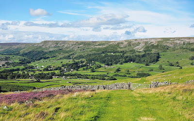
Fremington Edge

Reeth and Fremington Edge
I would argue that Gwen Ystrad is the valley of the Arkle Beck, or Arkengarthdale, named the White Strath for the white limestone cliffs flanking the river.
And the Llech Wen/White Stone?
Probably just a name for the scar itself, as opposed to the valley name. According to the GPC, llech did have the meaning of "cliff." Cf. the Welsh place-name Harlech, 'Fine Crag'.
On the ford in question, I have the following from Will Swale (personal communication):
"Only one of the north-bank dykes reaches anywhere near the River Swale – it’s the one that passes through Fremington village and then crosses the flood plain of Arkle Beck towards its confluence with the Swale.
The other one north of the Swale is higher up Arkle Beck (both are on its east side).
There would certainly have been a ford between them, crossing Arkle Beck, where now stands Reeth Bridge, carrying the main road connecting Fremington and Reeth.
The fords over the Swale in this general area would have been at what is now Grinton Bridge, and higher upstream at Scabba Wath, which isn’t at what the OS map wrongly calls Scabba Wath Bridge (known to indigenous locals always as Whita Bridge).
The ford of Scabba Wath is still visible about 300 metres downstream of Whita Bridge, where Browna Gill Beck enters the Swale, and where the OS map marks a cattle grid in the road.
These are the only crossing points near the dykes that are obvious today."
[1]
Catraeth's men set out at daybreak
Round a battle-winning lord, cattle-raiser.
Urien he, renowned chieftain,
Constrains rulers and cuts them down,
Eager for war, true leader of Christendom.
Prydain's men, they came in war-bands:
Gwen Ystrad your base, battle-honer.
Neither field nor forest shielded,
Land's protector, your foe when he came.
Like waves roaring harsh over land
I saw savage men in war-bands.
And after morning's fray, torn flesh.
I saw hordes of invaders dead;
Joyous, wrathful, the shout one heard.
Defending Gwen Ystrad one saw
A thin rampart and lone weary men.
At the ford I saw men stained with blood
Down arms before a grey-haired lord.
They wish peace, for they found the way barred,
Hands crossed, on the strand, cheeks pallid.
Their lords marvel at Idon's lavish wine;
Waves wash the tails of their horses.
I saw pillaging men disheartened,
And blood spattered on garments,
And quick groupings, ranks closed, for battle.
Battle's cloak, he'd no mind to flee,
Rheged's lord, I marvel, when challenged.
I saw splendid men around Urien
When he fought his foes at Llech Wen.
Routing does in fury delights him.
Carry, warriors, shields at the ready;
Battle's the lot of those who serve Urien.
And until I die, old,
By death's strict demand,
I shall not be joyful
Unless I praise Urien.
No comments:
Post a Comment
Note: Only a member of this blog may post a comment.